IMAGES TAKEN NEAR TO
Browns Lane, PULBOROUGH, RH20 4LQ
Introduction
This page details the photographs taken nearby to Browns Lane, RH20 4LQ by members of the Geograph project.
The Geograph project started in 2005 with the aim of publishing, organising and preserving representative images for every square kilometre of Great Britain, Ireland and the Isle of Man.

There are currently over 7.5m images from over14,400 individuals and you can help contribute to the project by visiting https://www.geograph.org.uk
Image Map
Images are licensed for reuse under creativecommons.org/licenses/by-sa/2.0
Notes
- Clicking on the map will re-center to the selected point.
- The higher the marker number, the further away the image location is from the centre of the postcode.
Image Listing (136 Images Found)
Images are licensed for reuse under creativecommons.org/licenses/by-sa/2.0
Image
Details
Distance
1
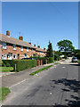
Browns Lane
The older lane becomes the newer Meadowside further down the road. Housing estate built on the southern side of the Storrington's High Street.
Image: © Simon Carey
Taken: 30 May 2009
0.02 miles
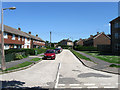
2
Meadowside
Housing estate to the south of Storrington's High Street. A low flying crow has decided to be a part of the picture.
Image: © Simon Carey
Taken: 30 May 2009
0.08 miles
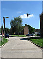
4
Ravenscroft
Housing estate on the southern edge of Storrington.
Image: © Simon Carey
Taken: 30 May 2009
0.09 miles
5
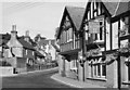
The Anchor Inn
Street scene at Storrington in about 1951. In foreground the Anchor Inn.
Image: © Les Whitcomb
Taken: Unknown
0.09 miles
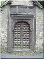
6
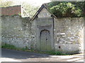
Wonderful Carved Door in Browns Lane
Now this something we didn't expect to find when out for a walk.
Image: © Josie Campbell
Taken: 7 May 2012
0.11 miles
7
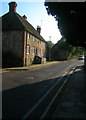
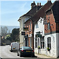
31-33 Church Street
The nearest is called Sycamore Cottage whilst the furthest lacks a name. Both are on the junction with Browns Lane with a doorway that leads into the grounds of the former St Josephs Abbey.
Image: © Simon Carey
Taken: 11 Oct 2008
0.11 miles
8
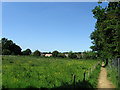
Diverted Footpath
Abbey House is currently being redeveloped so the footpath that ran through its grounds has now been diverted into the field next to it and been given an all weather surface to boot. Beyond the fence at the end of the field are Storrington's allotments.
Image: © Simon Carey
Taken: 30 May 2009
0.11 miles
10
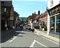
Storrington - Church Street
In the centre of Storrington looking towards the South Downs.
Image: © Nigel Freeman
Taken: 9 Aug 2005
0.12 miles