IMAGES TAKEN NEAR TO
Pulborough Road, PULBOROUGH, RH20 4HP
Introduction
This page details the photographs taken nearby to Pulborough Road, RH20 4HP by members of the Geograph project.
The Geograph project started in 2005 with the aim of publishing, organising and preserving representative images for every square kilometre of Great Britain, Ireland and the Isle of Man.

There are currently over 7.5m images from over14,400 individuals and you can help contribute to the project by visiting https://www.geograph.org.uk
Image Map (Loading...)


Getting Data...Please wait
Leaflet Map data © OpenStreetMap
Images are licensed for reuse under creativecommons.org/licenses/by-sa/2.0
Notes
- Clicking on the map will re-center to the selected point.
- The higher the marker number, the further away the image location is from the centre of the postcode.
Image Listing (30 Images Found)
Images are licensed for reuse under creativecommons.org/licenses/by-sa/2.0
Image
Details
Distance
1
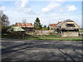
Charity Farm, Cootham
Built on the boundary of Cootham Common which once lined either side of the road to Pulborough. The farm house is behind the barn which is currently being converted into a residence.
Image: © Simon Carey
Taken: 5 Apr 2009
0.01 miles
3

Rain stops play at Parham Airfield
Gliders and tug grounded while the storm passes through on a hot June afternoon.
Image: © Chris
Taken: 14 Jun 2014
0.06 miles
4
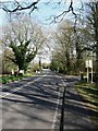
Pulborough Road, Cootham
The A283 heads toward Storrington from Pulborough. Clay Lane is the road on the right.
Image: © Simon Carey
Taken: 5 Apr 2009
0.09 miles
5
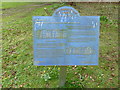
Heritage Trail board in Parham Estate
It gives a brief history of Parham House notably the name was first mentioned in 959AD from the words meaning 'Pear Tree Settlement'.
Image: © Dave Spicer
Taken: 2 Apr 2011
0.10 miles
6
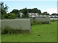
Glider coffins?
On the perimeter of the Southdown Gliding Club's airfield are several lock-up sheds tailored to the shape of the glider, which goes in nose first. Brief research failed to find the proper name for these, but coffin seems apt.
Image: © Robin Webster
Taken: 23 Jun 2011
0.11 miles
7
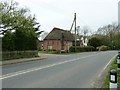
Cootham Village Hall
At one time it was a Mission Chapel.
Image: © Dave Spicer
Taken: 2 Apr 2011
0.14 miles
8
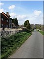
Clay Lane
Minor road linking the B2139 Amberley Road with the A283 Pulborough Road. Rod Cottage is on the left whilst Lower Barn is just visible further down the lane.
Image: © Simon Carey
Taken: 5 Apr 2009
0.14 miles
9
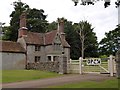
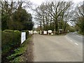
The eastern gatehouse for Parham Park
Visitors do not use this gate; they use a modern alternative to one side. The Victorian gatehouse is known as Douglas' Lodge
Image: © David Smith
Taken: 5 Jul 2015
0.15 miles
10
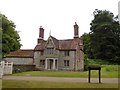
Douglas's Lodge, the eastern gatehouse for Parham Park
On the right-hand side of the Victorian building, the flues are traced in brick. The architect decided on a pattern of symmetry for the chimneys in the gables, which meant that the flues are not vertical
Image: © David Smith
Taken: 5 Jul 2015
0.15 miles