IMAGES TAKEN NEAR TO
Meadowside, PULBOROUGH, RH20 4EQ
Introduction
This page details the photographs taken nearby to Meadowside, RH20 4EQ by members of the Geograph project.
The Geograph project started in 2005 with the aim of publishing, organising and preserving representative images for every square kilometre of Great Britain, Ireland and the Isle of Man.

There are currently over 7.5m images from over14,400 individuals and you can help contribute to the project by visiting https://www.geograph.org.uk
Image Map
Images are licensed for reuse under creativecommons.org/licenses/by-sa/2.0
Notes
- Clicking on the map will re-center to the selected point.
- The higher the marker number, the further away the image location is from the centre of the postcode.
Image Listing (140 Images Found)
Images are licensed for reuse under creativecommons.org/licenses/by-sa/2.0
Image
Details
Distance
1
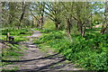
Browns Lane
The older lane becomes the newer Meadowside further down the road. Housing estate built on the southern side of the Storrington's High Street.
Image: © Simon Carey
Taken: 30 May 2009
0.05 miles
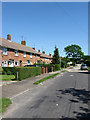
2
Meadowside
Housing estate to the south of Storrington's High Street. A low flying crow has decided to be a part of the picture.
Image: © Simon Carey
Taken: 30 May 2009
0.07 miles
3
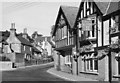
The Anchor Inn
Street scene at Storrington in about 1951. In foreground the Anchor Inn.
Image: © Les Whitcomb
Taken: Unknown
0.08 miles

5
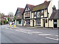
The Anchor Inn, Storrington
This friendly pub with a good reputation for food is on the High Street.
Image: © Maigheach-gheal
Taken: 25 May 2009
0.09 miles
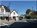
6

Sign for the Anchor Inn, Storrington
This common sign was probably first used as a convenient visual symbol, especially by landlords who had connections with the sea or wish to attract seamen as customers.
Image: © Maigheach-gheal
Taken: 25 May 2009
0.10 miles
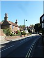
7

Telephone box, Storrington
K6 type telephone box on the High Street.
Image: © Maigheach-gheal
Taken: 25 May 2009
0.10 miles
9
Looking east-southeast along Manley's Hill
Image: © Basher Eyre
Taken: 29 Sep 2011
0.10 miles