IMAGES TAKEN NEAR TO
London Road, PULBOROUGH, RH20 4DG
Introduction
This page details the photographs taken nearby to London Road, RH20 4DG by members of the Geograph project.
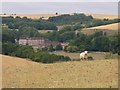
The Geograph project started in 2005 with the aim of publishing, organising and preserving representative images for every square kilometre of Great Britain, Ireland and the Isle of Man.

There are currently over 7.5m images from over14,400 individuals and you can help contribute to the project by visiting https://www.geograph.org.uk
Image Map (Loading...)


Getting Data...Please wait
Leaflet Map data © OpenStreetMap
Images are licensed for reuse under creativecommons.org/licenses/by-sa/2.0
Notes
- Clicking on the map will re-center to the selected point.
- The higher the marker number, the further away the image location is from the centre of the postcode.
Image Listing (25 Images Found)
Images are licensed for reuse under creativecommons.org/licenses/by-sa/2.0
Image
Details
Distance
1
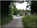
Bridleway 2016 from Windlesham school to Highden Barn
Image: © Dave Spicer
Taken: 1 Aug 2009
0.06 miles
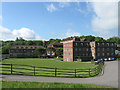
2

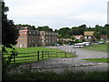
Older buildings at Windlesham House School
This range of buildings now seems to be used for residential purposes.
Image: © Robin Webster
Taken: 27 May 2011
0.07 miles
3
Windlesham House School
Originally a country residence called Highden House that existed here from the 16th century and was rebuilt during the reign of Queen Anne. The house was purchased by Windlesham School in 1934 who consequently moved from their former site in Brighton the following year and have remained here ever since. The school is an independent preparatory co-educational boarding establishment catering for 9 to 13 year olds.
Image: © Simon Carey
Taken: 27 May 2013
0.08 miles
4
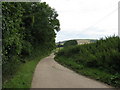
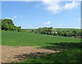
View north towards Windlesham school
The South Downs Way follows the skyline eastwards towards the River Adur near Bramber
Image: © Dave Spicer
Taken: 1 Aug 2009
0.08 miles
5
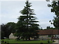
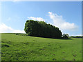
Fine Conifer in the grounds of Windlesham House School
Image: © Dave Spicer
Taken: 1 Aug 2009
0.09 miles
6
Dog Kennel Field
The name of the field according to Washington's 1839 tithe map with the former outbuildings of the old Highden House, now Windlesham House School, visible in the distance to the right, probably one of them housing the titular kennels. The white building just visible through the trees in the centre is the current Highden House which seems to have been built before the Second World War.
Image: © Simon Carey
Taken: 27 May 2013
0.09 miles
7
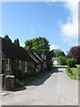
1-4 The Square, Windlesham House School
These flint cottages seem to date from the end of the 19th century to serve what was then Highden House. A lot of the outbuildings that once served the former house have now been converted to residential use though I am uncertain whether all are connected with the school. The name, The Square, first appears on post war maps.
Image: © Simon Carey
Taken: 27 May 2013
0.10 miles
8
Cow Down (1)
The name of the field according to Washington's 1839 tithe map viewed from the bridleway that links Windlesham House School to Findon. See also Image
Image: © Simon Carey
Taken: 27 May 2013
0.10 miles
9
Windlesham House School
The school is currently in its 75th year at this location
Image: © Dave Spicer
Taken: 1 Aug 2009
0.10 miles
10
Windlesham House School
The school is seen from a byway on the downs. North Farm and the A24 are hidden in the valley.
Image: © Shazz
Taken: 30 Jul 2010
0.11 miles