IMAGES TAKEN NEAR TO
The Street, PULBOROUGH, RH20 4AS
Introduction
This page details the photographs taken nearby to The Street, RH20 4AS by members of the Geograph project.
The Geograph project started in 2005 with the aim of publishing, organising and preserving representative images for every square kilometre of Great Britain, Ireland and the Isle of Man.

There are currently over 7.5m images from over14,400 individuals and you can help contribute to the project by visiting https://www.geograph.org.uk
Image Map (Loading...)


Getting Data...Please wait
Leaflet Map data © OpenStreetMap
Images are licensed for reuse under creativecommons.org/licenses/by-sa/2.0
Notes
- Clicking on the map will re-center to the selected point.
- The higher the marker number, the further away the image location is from the centre of the postcode.
Image Listing (119 Images Found)
Images are licensed for reuse under creativecommons.org/licenses/by-sa/2.0
Image
Details
Distance
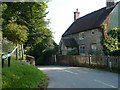
2
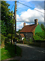
Cottage, School Lane
On the junction of that lane and The Street. Most of the building is of flint except the southern side which seems to be of corrugated iron.
Image: © Simon Carey
Taken: 2 Oct 2008
0.02 miles
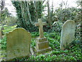
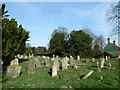
3
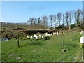
Graveyard, The Street
Separate from St Mary's Church which lies a little way down the road. The building at the end of the graveyard is Bank Cottage.
Image: © Simon Carey
Taken: 2 Oct 2008
0.02 miles
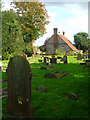
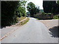
4
Looking from the old graveyard into School Lane
Image: © Basher Eyre
Taken: 12 Mar 2011
0.03 miles
5
School Lane, Washington
Seen at the junction with The Street, near the church.
Image: © pam fray
Taken: 18 Sep 2008
0.03 miles
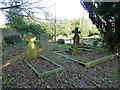
6
Washington- old graveyard (4)
Looking towards a cottage in School Lane.
Image: © Basher Eyre
Taken: 12 Mar 2011
0.03 miles
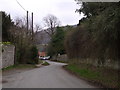
7
The Street, Washington
Eastwards up The Street, a narrow lane on the west side of the village which accesses the church and Rowdell Farm, forming part of the South Downs Way route. The cyclist just visible in the shade of the wall & trees on the right is a participant in the 2015 British Heart Foundation's organised ride along the full 100-mile length of the South Downs Way. He's delighted to be at the bottom of another 500' climb, and looking forward to aching legs on the way back up onto the ridge.
Image: © Richard Law
Taken: 18 Jul 2015
0.03 miles
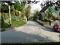
10
The Street, Washington, West Sussex
The red brick house denotes the junction. A left turn takes us back into the village.
Image: © nick macneill
Taken: 1 Feb 2009
0.04 miles