IMAGES TAKEN NEAR TO
Vineyards Close, Old London Road, RH20 3RA
Introduction
This page details the photographs taken nearby to Vineyards Close, Old London Road, RH20 3RA by members of the Geograph project.
The Geograph project started in 2005 with the aim of publishing, organising and preserving representative images for every square kilometre of Great Britain, Ireland and the Isle of Man.

There are currently over 7.5m images from over14,400 individuals and you can help contribute to the project by visiting https://www.geograph.org.uk
Image Map (Loading...)


Getting Data...Please wait
Leaflet Map data © OpenStreetMap
Images are licensed for reuse under creativecommons.org/licenses/by-sa/2.0
Notes
- Clicking on the map will re-center to the selected point.
- The higher the marker number, the further away the image location is from the centre of the postcode.
Image Listing (41 Images Found)
Images are licensed for reuse under creativecommons.org/licenses/by-sa/2.0
Image
Details
Distance
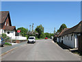
1
Montpelier Gardens, Rock
The land here was once part of Washington Common until enclosure in the mid 19th century. After that it was used for market gardening and after the First World War parts began to be developed such as this small estate built by the council in the 1930s.
Image: © Simon Carey
Taken: 27 May 2013
0.07 miles
2
Goodyers Farm, Rock
Built in 1773 at the old crossroads containing London Road, Rock Road and The Hollow. The current A24 bypasses it to the east. The building was formerly known as Rock Farm.
Image: © Simon Carey
Taken: 27 May 2013
0.08 miles
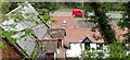
3
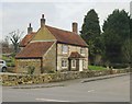
Goodyers Farm, Old London Road, Rock
The house faces on to a roadway which was - until half a century ago - the main London road. Joining from the left is a minor road that leads to Thakeham and Warminghurst. According to Simon Carey (who has researched the history of this area in great detail) the farmhouse was built in 1773 and was originally known as Rock Farm: http://www.geograph.org.uk/photo/3486984
As for building materials, the single-storey section nearest the camera appears to be built of the dark but variable sandstone known in Surrey as Bargate stone. The pale stone of the main part of the building could well be clunch - chalk.
Image: © Stefan Czapski
Taken: 4 Mar 2017
0.08 miles
4
Rock Lane, Rock
A private road that links Old London Road to Rock Road. It is the northern end of the small hamlet of Rock whose derivation comes from the old English 'atter oke' or at the oak as opposed to anything to do with stones.
Image: © Simon Carey
Taken: 27 May 2013
0.09 miles
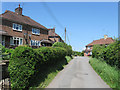
5
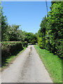
Old London Road, Washington
Now a dead-end in each direction, with access to properties from Rock Road, crossing in the foreground.
Image: © Robin Webster
Taken: 27 Jun 2019
0.09 miles
6
Washington House, Rock
Home to HGH Groundworks Ltd. Once part of Washington Common the entrance to the works once contained a small sand pit and after enclosure much of the land became orchards until some were developed in the 1930s though this strip was not developed until after the Second World War.
Image: © Simon Carey
Taken: 27 May 2013
0.13 miles
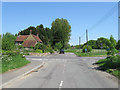
7
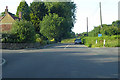
Old London Road, Rock
The former course of the A24 as it passes through the hamlet north of Washington. When Washington's bypass was built in 1964 it was also dualled north of the new roundabout bypassing the hamlet in the process. On the left is Harmston House whilst to the right is The Old Smithy which has now been converted into a restaurant.
Image: © Simon Carey
Taken: 27 May 2013
0.13 miles
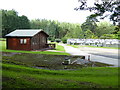
8
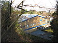
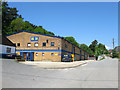
Birds eye view of industrial unit by Washington Common
Image: © Dave Spicer
Taken: 2 Jan 2011
0.14 miles