IMAGES TAKEN NEAR TO
The Mews, London Road, PULBOROUGH, RH20 3QH
Introduction
This page details the photographs taken nearby to The Mews, London Road, RH20 3QH by members of the Geograph project.
The Geograph project started in 2005 with the aim of publishing, organising and preserving representative images for every square kilometre of Great Britain, Ireland and the Isle of Man.

There are currently over 7.5m images from over14,400 individuals and you can help contribute to the project by visiting https://www.geograph.org.uk
Image Map
Images are licensed for reuse under creativecommons.org/licenses/by-sa/2.0
Notes
- Clicking on the map will re-center to the selected point.
- The higher the marker number, the further away the image location is from the centre of the postcode.
Image Listing (76 Images Found)
Images are licensed for reuse under creativecommons.org/licenses/by-sa/2.0
Image
Details
Distance
1
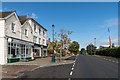
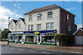
London Road
Looking north along London Road. On the left is Clearview House, containing a pharmacy and a flooring retailer.
Image: © Ian Capper
Taken: 30 Sep 2016
0.02 miles
2
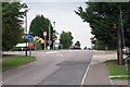
London Road, Ashington
Looking north from the southern end of the village. Once, as its name suggests, this was the main A24 London to Worthing road. Now the traffic has been diverted away onto a bypass and the main street has been traffic-calmed. In recent years the village has developed from being a straggle along the main road into a substantial dormitory village. Surprisingly, the church is on the outskirts of the village. This may be because a Roman building, possibly a villa, existed at Church Farm and maybe the original church was associated with it.
Image: © Ron Strutt
Taken: 10 Sep 2005
0.02 miles
3
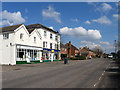
Shops, London Road
The two buildings contain the village pharmacy and a flooring company and date from the 19th century. The former was for many decades the village post office.
Image: © Simon Carey
Taken: 2 Apr 2013
0.02 miles
4
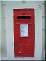
Georgian Post Box
Georgian Post Box RH20 36 Holloways Stores. Built in to wall of building what is now a Pharmacy & Floorings shop.
Image: © The Saunterer
Taken: 12 May 2012
0.03 miles
5
Clearview House
Building in London Road containing a pharmacy and a flooring retailer. The building is marked on the 1875 1:2500 and shown then as a Post Office, a role it continued to play until at least the 1980s.
Image: © Ian Capper
Taken: 30 Sep 2016
0.03 miles
7
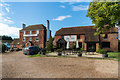
The Red Lion
18th Century grade II listed inn - see https://www.historicengland.org.uk/listing/the-list/list-entry/1354091. On the right are the former stables, also dating from the 18th Century and separately grade II listed - see https://www.historicengland.org.uk/listing/the-list/list-entry/1284725.
Image: © Ian Capper
Taken: 30 Sep 2016
0.04 miles
8
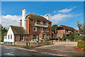
The Red Lion
18th Century grade II listed inn - see https://www.historicengland.org.uk/listing/the-list/list-entry/1354091. On the right are the former stables, also dating from the 18th Century and separately grade II listed - see https://www.historicengland.org.uk/listing/the-list/list-entry/1284725.
Image: © Ian Capper
Taken: 30 Sep 2016
0.05 miles
9
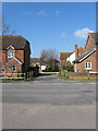
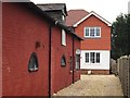
Blacksmiths Close
A small cul de sac off London Road built on the site of an old filling station during the 1990s. Named after the former village blacksmiths which was once located nearby.
Image: © Simon Carey
Taken: 2 Apr 2013
0.05 miles
10
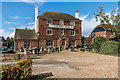
The Red Lion
18th Century grade II listed inn - see https://www.historicengland.org.uk/listing/the-list/list-entry/1354091.
Image: © Ian Capper
Taken: 30 Sep 2016
0.05 miles