IMAGES TAKEN NEAR TO
Bracken Close, PULBOROUGH, RH20 3HT
Introduction
This page details the photographs taken nearby to Bracken Close, RH20 3HT by members of the Geograph project.
The Geograph project started in 2005 with the aim of publishing, organising and preserving representative images for every square kilometre of Great Britain, Ireland and the Isle of Man.

There are currently over 7.5m images from over14,400 individuals and you can help contribute to the project by visiting https://www.geograph.org.uk
Image Map
Images are licensed for reuse under creativecommons.org/licenses/by-sa/2.0
Notes
- Clicking on the map will re-center to the selected point.
- The higher the marker number, the further away the image location is from the centre of the postcode.
Image Listing (6 Images Found)
Images are licensed for reuse under creativecommons.org/licenses/by-sa/2.0
Image
Details
Distance
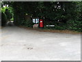
2
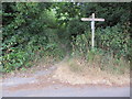
Short path to Hampers Lane
Fingerpost at junction of Public footpaths 2625/1 (north) and 2625.
Image: © Peter Holmes
Taken: 20 Jul 2013
0.13 miles
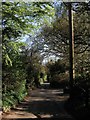
3
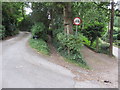
Path between driveways
Public footpath 2625 leading to Veras Walk.
Image: © Peter Holmes
Taken: 20 Jul 2013
0.15 miles
4
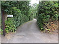
Footpath to Rock Road
Public footpath 2625. A fingerpost would be useful here as the footpath leaves Bracken Lane.
Image: © Peter Holmes
Taken: 20 Jul 2013
0.19 miles
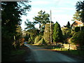
6
Hampers Lane
The lane links Storrington Road, the A283, with Rock Road, and for much of its course is the parish boundary between Washington on the left and Sullington to the right.
Image: © Simon Carey
Taken: 6 May 2013
0.25 miles