IMAGES TAKEN NEAR TO
Storrington Road, PULBOROUGH, RH20 3EE
Introduction
This page details the photographs taken nearby to Storrington Road, RH20 3EE by members of the Geograph project.
The Geograph project started in 2005 with the aim of publishing, organising and preserving representative images for every square kilometre of Great Britain, Ireland and the Isle of Man.

There are currently over 7.5m images from over14,400 individuals and you can help contribute to the project by visiting https://www.geograph.org.uk
Image Map
Images are licensed for reuse under creativecommons.org/licenses/by-sa/2.0
Notes
- Clicking on the map will re-center to the selected point.
- The higher the marker number, the further away the image location is from the centre of the postcode.
Image Listing (13 Images Found)
Images are licensed for reuse under creativecommons.org/licenses/by-sa/2.0
Image
Details
Distance
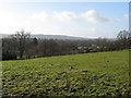
1
Looking across Storrington Road from bridleway
Image: © Shazz
Taken: 28 Aug 2015
0.04 miles
4
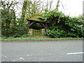
Gate shelter or lean-to?
Fortunately the residents do not appear to use this entrance.
Image: © Dave Spicer
Taken: 2 Apr 2011
0.08 miles
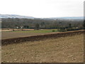
5
View SW from hillside footpath south of Abingworth
Image: © Dave Spicer
Taken: 17 Jan 2010
0.14 miles
6
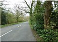
Greenhurst Lane
West to West Chiltington.
Image: © Dave Spicer
Taken: 2 Apr 2011
0.14 miles
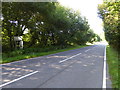
7
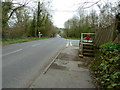
B2139 north to Thakeham
The course of an old Roman Road crosses diagonally where the postbox is.
Image: © Dave Spicer
Taken: 2 Apr 2011
0.15 miles
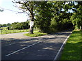
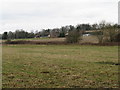
9
View to houses on the B2139
South Downs in the background
Image: © Dave Spicer
Taken: 28 Feb 2009
0.19 miles
10
Green Dene Farm
This farm is alongside the B2139 at a point called Jacket's Hill
Image: © Dave Spicer
Taken: 28 Feb 2009
0.19 miles