IMAGES TAKEN NEAR TO
Wiggonholt, PULBOROUGH, RH20 2EJ
Introduction
This page details the photographs taken nearby to Wiggonholt, RH20 2EJ by members of the Geograph project.
The Geograph project started in 2005 with the aim of publishing, organising and preserving representative images for every square kilometre of Great Britain, Ireland and the Isle of Man.

There are currently over 7.5m images from over14,400 individuals and you can help contribute to the project by visiting https://www.geograph.org.uk
Image Map (Loading...)


Getting Data...Please wait
Leaflet Map data © OpenStreetMap
Images are licensed for reuse under creativecommons.org/licenses/by-sa/2.0
Notes
- Clicking on the map will re-center to the selected point.
- The higher the marker number, the further away the image location is from the centre of the postcode.
Image Listing (7 Images Found)
Images are licensed for reuse under creativecommons.org/licenses/by-sa/2.0
Image
Details
Distance
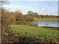
3
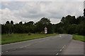
A283 Near Pulborough
Looking away from Pulborough, and close to the Pulborough Brooks nature reserve.
Image: © Peter Trimming
Taken: 2 Jun 2014
0.16 miles
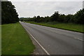
4
Running Deer
Near River Chilt, looking across grazing land towards Winterfield Farm.
Image: © Peter Holmes
Taken: 3 Aug 2013
0.17 miles
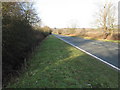
5
A283 Near Pulborough
Looking towards Pulborough, and close to the Pulborough Brooks nature reserve.
Image: © Peter Trimming
Taken: 2 Jun 2014
0.21 miles
6
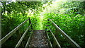
Bridge over the River Chilt
This is on the West Sussex Literary Trail near West Chiltington.
Image: © Shazz
Taken: 11 Aug 2008
0.24 miles
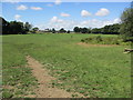
7
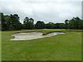
A fortunate lie
The golf course was busy, so the lookout was for active golfers in the distance, not things close, so this ball was only noticed on looking at the photograph!
Image: © Robin Webster
Taken: 21 Jun 2011
0.24 miles