IMAGES TAKEN NEAR TO
Portland Road, EAST GRINSTEAD, RH19 4EZ
Introduction
This page details the photographs taken nearby to Portland Road, RH19 4EZ by members of the Geograph project.
The Geograph project started in 2005 with the aim of publishing, organising and preserving representative images for every square kilometre of Great Britain, Ireland and the Isle of Man.

There are currently over 7.5m images from over14,400 individuals and you can help contribute to the project by visiting https://www.geograph.org.uk
Image Map
Images are licensed for reuse under creativecommons.org/licenses/by-sa/2.0
Notes
- Clicking on the map will re-center to the selected point.
- The higher the marker number, the further away the image location is from the centre of the postcode.
Image Listing (615 Images Found)
Images are licensed for reuse under creativecommons.org/licenses/by-sa/2.0
Image
Details
Distance
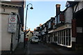
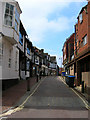
2
The old houses and shops at East Grinstead
The top end of East Grinstead has not changed much for 100s of years. Many of the wood framed buildings still stand and the Town Church dominates.
Image: © Nigel Freeman
Taken: 24 Jun 2005
0.02 miles
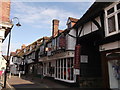
3

East Grinstead High Street
Photograph taken from the small road which runs behind the current High Street. The appearance of the buildings, to the left of picture, suggests that this was the original High Street.
Image: © Peter Trimming
Taken: 25 Jun 2014
0.02 miles
4
High Street (A22), East Grinstead
At its junction with London Road (A22) to the left
Image: © John Baker
Taken: 4 May 2011
0.03 miles
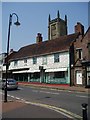
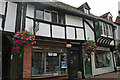
5
40 to 34 High Street, East Grinstead
Grade II Listed shop with 14th century timber framing formerly the site of the Lion Inn mentioned in a will of 1619. The building actually comprises two medieval structures, 36-40 having a broad frontage parallel to the street, and 34 representing a range at right-angles to the street; the presence of a primary cart entrance could suggest a courtyard plan from the outset. The front range, which has an aisled hall, has been dated by dendrochronology to 1352.
Image: © Jo and Steve Turner
Taken: 20 Sep 2009
0.03 miles
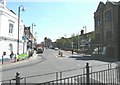
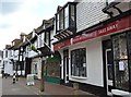
6
Middle Row
Taken from the junction with Portland Road. Some of the houses date from the 1350s and have often been expanded during other periods, Wilmington House, the first on the left, has an Elizabethan east wing grafted onto an older 14th century hall house that dates from around 1352. The buildings on the right are the rear parts of the shops on High Street.
Image: © Simon Carey
Taken: 20 Apr 2008
0.03 miles
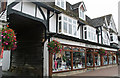
7
No.42 and No.44, East Grinstead High Street
A pair of Grade II listed timber-framed buildings on the pedestrianised section of the High Street.
See http://www.britishlistedbuildings.co.uk/en-430563-42-and-44-east-grinstead for more details about the buildings.
Image: © David Anstiss
Taken: 16 May 2012
0.03 miles
8
46A and 46 High Street, East Grinstead
Grade II Listed, Susie's Dress Agency is 46 High street and prior to its closure in 2012 after 44 years trading Inmates was numbered 46A High Street. A photograph of G H Lynn & Son monumental masons taken about 1919-20 clearly shows 46 over the door of Inmates. So up to the early 20th century 46 and 46A were still one business but with two doors, presumably one to the showroom (Susie's) where stone crosses are visible through the window and one to the living accommodation (Inmates). Conversely, Nizam's number 42 is clearly marked in the picture as number 44 G W Wheatland Baker, as 42 and 44 have now combined to one business.
Image: © Jo and Steve Turner
Taken: 20 Sep 2009
0.03 miles
9
Nizam Indian
Grade II listed. http://www.britishlistedbuildings.co.uk/en-430563-42-and-44-high-street-east-grinstead-wes
Image: © N Chadwick
Taken: 23 May 2016
0.03 miles
10
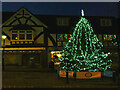
Christmas Day Morning - East Grinstead High Street
Image: © Ed of the South
Taken: 25 Dec 2019
0.03 miles