IMAGES TAKEN NEAR TO
Hammerwood Gardens, EAST GRINSTEAD, RH19 3UZ
Introduction
This page details the photographs taken nearby to Hammerwood Gardens, RH19 3UZ by members of the Geograph project.
The Geograph project started in 2005 with the aim of publishing, organising and preserving representative images for every square kilometre of Great Britain, Ireland and the Isle of Man.

There are currently over 7.5m images from over14,400 individuals and you can help contribute to the project by visiting https://www.geograph.org.uk
Image Map
Images are licensed for reuse under creativecommons.org/licenses/by-sa/2.0
Notes
- Clicking on the map will re-center to the selected point.
- The higher the marker number, the further away the image location is from the centre of the postcode.
Image Listing (51 Images Found)
Images are licensed for reuse under creativecommons.org/licenses/by-sa/2.0
Image
Details
Distance
3
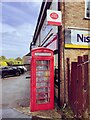
Telephone Kiosk with Deliberator Maypole Road
Image: © PAUL FARMER
Taken: 8 Sep 2022
0.07 miles
6
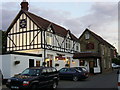
The Maypole
76 Maypole Road, Ashurst Wood. The village seems to have decided within the last thrity years that it is two words and not Ashurstwood as on older maps
Image: © Roger W Haworth
Taken: 9 Aug 2006
0.09 miles
7
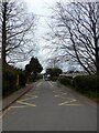
School Lane, Ashurstwood
Connecting Hammerwood Road to Woods Hill Lane with Ashurstwood County Primary School on the right.
Image: © Simon Carey
Taken: 7 Apr 2021
0.09 miles