IMAGES TAKEN NEAR TO
Blackwell Farm Road, EAST GRINSTEAD, RH19 3HX
Introduction
This page details the photographs taken nearby to Blackwell Farm Road, RH19 3HX by members of the Geograph project.
The Geograph project started in 2005 with the aim of publishing, organising and preserving representative images for every square kilometre of Great Britain, Ireland and the Isle of Man.

There are currently over 7.5m images from over14,400 individuals and you can help contribute to the project by visiting https://www.geograph.org.uk
Image Map
Images are licensed for reuse under creativecommons.org/licenses/by-sa/2.0
Notes
- Clicking on the map will re-center to the selected point.
- The higher the marker number, the further away the image location is from the centre of the postcode.
Image Listing (111 Images Found)
Images are licensed for reuse under creativecommons.org/licenses/by-sa/2.0
Image
Details
Distance
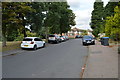
9
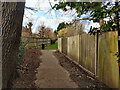
Public footpath 1dEG, East Grinstead
From St Johns Road through Mount Noddy recreation ground and cemetery to Badgers Way just round the corner. It continues under a different affix to Holtye Road by the Queen Victoria Hospital.
Image: © Robin Webster
Taken: 6 Mar 2022
0.05 miles
10
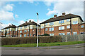
Flats, Blackwell Farm Road, East Grinstead
A rear view from Badgers Way.
Image: © Robin Webster
Taken: 6 Mar 2022
0.06 miles