IMAGES TAKEN NEAR TO
Holtye Road, EAST GRINSTEAD, RH19 3HT
Introduction
This page details the photographs taken nearby to Holtye Road, RH19 3HT by members of the Geograph project.
The Geograph project started in 2005 with the aim of publishing, organising and preserving representative images for every square kilometre of Great Britain, Ireland and the Isle of Man.

There are currently over 7.5m images from over14,400 individuals and you can help contribute to the project by visiting https://www.geograph.org.uk
Image Map
Images are licensed for reuse under creativecommons.org/licenses/by-sa/2.0
Notes
- Clicking on the map will re-center to the selected point.
- The higher the marker number, the further away the image location is from the centre of the postcode.
Image Listing (111 Images Found)
Images are licensed for reuse under creativecommons.org/licenses/by-sa/2.0
Image
Details
Distance
1
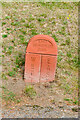
Meridian marker, Lynton Park Avenue
Terracotta meridian marker in Lynton Park Avenue, one of at least 12 installed in 2000 to mark the line of the Greenwich Meridian through East Grinstead.
Image: © Ian Capper
Taken: 26 Sep 2023
0.04 miles
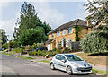
2
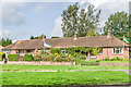
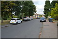
25 - 31 Holtye Road
Terrace of bungalows on Holtye Road by its junction with Blackwell Farm Road, first marked on the 1957 1:2500 map.
Image: © Ian Capper
Taken: 26 Sep 2023
0.04 miles
3
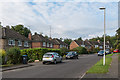
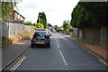
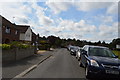
Lynton Park Avenue
1970s housing south of Holtye Road.
Image: © Ian Capper
Taken: 14 Oct 2016
0.06 miles
4
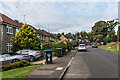
Lynton Park Avenue
1970s housing south of Holtye Road.
Image: © Ian Capper
Taken: 14 Oct 2016
0.06 miles
7
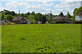
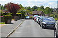
Lynton Park Avenue
1970s housing south of Holtye Road.
Image: © Ian Capper
Taken: 26 Sep 2023
0.07 miles