IMAGES TAKEN NEAR TO
Sandhawes Hill, EAST GRINSTEAD, RH19 3ET
Introduction
This page details the photographs taken nearby to Sandhawes Hill, RH19 3ET by members of the Geograph project.
The Geograph project started in 2005 with the aim of publishing, organising and preserving representative images for every square kilometre of Great Britain, Ireland and the Isle of Man.

There are currently over 7.5m images from over14,400 individuals and you can help contribute to the project by visiting https://www.geograph.org.uk
Image Map
Images are licensed for reuse under creativecommons.org/licenses/by-sa/2.0
Notes
- Clicking on the map will re-center to the selected point.
- The higher the marker number, the further away the image location is from the centre of the postcode.
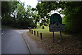
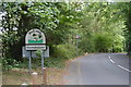
Image Listing (37 Images Found)
Images are licensed for reuse under creativecommons.org/licenses/by-sa/2.0
Image
Details
Distance
1
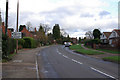
Woodlands Road
The beginning of an estate of semi-detached houses.
Image: © Oast House Archive
Taken: 4 Jul 2010
0.03 miles
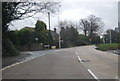
7
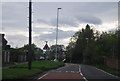
A264 in Stonequarry area of East Grinstead
The view looks approximately east along the A264 towards the junction with the minor road to Edenbridge - the braking white van is turning left into this road.
Image: © Robin Webster
Taken: 10 Jan 2007
0.08 miles
10
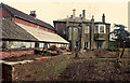
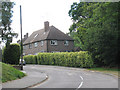
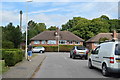
The Larches
Side view of main house of The Larches, showing greenhouse and part of former servants' quarters. Taken from just inside main Sandawes Hill gate.
Image: © spanishliz
Taken: Unknown
0.09 miles