IMAGES TAKEN NEAR TO
Eden Vale, EAST GRINSTEAD, RH19 2LT
Introduction
This page details the photographs taken nearby to Eden Vale, RH19 2LT by members of the Geograph project.
The Geograph project started in 2005 with the aim of publishing, organising and preserving representative images for every square kilometre of Great Britain, Ireland and the Isle of Man.

There are currently over 7.5m images from over14,400 individuals and you can help contribute to the project by visiting https://www.geograph.org.uk
Image Map
Images are licensed for reuse under creativecommons.org/licenses/by-sa/2.0
Notes
- Clicking on the map will re-center to the selected point.
- The higher the marker number, the further away the image location is from the centre of the postcode.
Image Listing (58 Images Found)
Images are licensed for reuse under creativecommons.org/licenses/by-sa/2.0
Image
Details
Distance
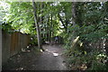
1
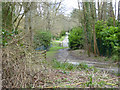
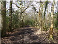
Eden Vale
A track from East Grinstead as far as the gate, it then becomes a private road of the Dormans Park estate. It is a public footpath throughout.
Image: © Robin Webster
Taken: 26 Feb 2020
0.12 miles
2
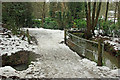
Two bridges
The near bridge takes the public bridleway over a side stream of the one seen at right. There is a far steel bridge over the main stream, possibly an old lorry deck frame, but lacking the deck and blocked with a garden fence at one end.
Image: © Robin Webster
Taken: 15 Jan 2010
0.13 miles
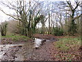
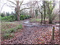
3
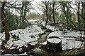
Stream south of bridleway
Looking upstream. The bridleway bridges the stream out of sight, in the foreground is a rather damaged culvert that seems to be intended for access to the land to the right of the stream, but long overgrown.
Image: © Robin Webster
Taken: 15 Jan 2010
0.14 miles
4
Lake View Road, Dormans Park
The lake is on the left, but the view from the road is obscured.
Image: © Robin Webster
Taken: 26 Feb 2020
0.14 miles
6
Track through woodland near East Grinstead
A track through woodland near East Grinstead. This image was taken in December 2019, after a spell of wet weather.
Image: © Malc McDonald
Taken: 14 Dec 2019
0.16 miles
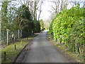
7
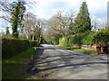
Furzefield Chase, Dormans Park
One of the main roads in the low density estate.
Image: © Robin Webster
Taken: 26 Feb 2020
0.16 miles
9
Tandridge Border Path & Greenwich Meridian Trail
Image: © N Chadwick
Taken: 31 Aug 2016
0.17 miles
10
Footpath marker near East Grinstead
A footpath marker post in woodland near East Grinstead. This image was taken in December 2019. The ground was carpeted with leaves which had fallen during the autumn, autumn 2019 had also been very wet, resulting in plenty of surface water which had not yet drained away.
Image: © Malc McDonald
Taken: 14 Dec 2019
0.17 miles