IMAGES TAKEN NEAR TO
Colchester Vale, FOREST ROW, RH18 5HH
Introduction
This page details the photographs taken nearby to Colchester Vale, RH18 5HH by members of the Geograph project.
The Geograph project started in 2005 with the aim of publishing, organising and preserving representative images for every square kilometre of Great Britain, Ireland and the Isle of Man.

There are currently over 7.5m images from over14,400 individuals and you can help contribute to the project by visiting https://www.geograph.org.uk
Image Map
Images are licensed for reuse under creativecommons.org/licenses/by-sa/2.0
Notes
- Clicking on the map will re-center to the selected point.
- The higher the marker number, the further away the image location is from the centre of the postcode.
Image Listing (17 Images Found)
Images are licensed for reuse under creativecommons.org/licenses/by-sa/2.0
Image
Details
Distance
1
Michael Fields, Forest Row
A cul de sac off Gage Ridge and part of development built on the northern part of Kidbrooke Park, whose previous owners are recorded in the road names.
Image: © Simon Carey
Taken: 12 Jun 2022
0.12 miles
2

Priory Road, Forest Row
Looking down the hill, towards the town centre. To the right/centre of picture, a major house conversion is taking place.
Image: © Peter Trimming
Taken: 25 Jun 2014
0.13 miles
3
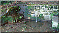
Spring
This spring is in Gilham Lane. The water is tested, but drink at your own risk.
Image: © cynthia hudson
Taken: 1 Jan 2010
0.16 miles
4

Priory Road, Forest Row
Looking up the hill, away from the town centre. Note the 40mph speed limit.
Image: © Peter Trimming
Taken: 25 Jun 2014
0.16 miles
5
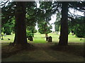
Forest Row Cemetery
Run by the Forest Row Parish Council with peaceful surroundings. Has won a 'Best cemetery in the South' Award !
Image: © Nigel Freeman
Taken: 24 Jun 2005
0.16 miles
6
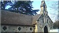
Cemetery chapel
This disused chapel is owned by Forest row Parish council as is the cemetery.
Image: © cynthia hudson
Taken: 15 Jan 2012
0.17 miles
7
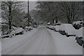
Priory Rd December 2010
Heaviest snowfall for years! 10 inches
Image: © Michael Cassels
Taken: Unknown
0.17 miles
8
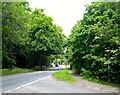
Lewes Road, Forest Row
Looking north from the junction with Highgate Road at the possible site of Highgate, one of the former medieval entrances to Ashdown Forest.
Image: © Simon Carey
Taken: 12 Jun 2022
0.18 miles
9
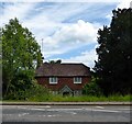
Hazel Cottage, Lewes Road, Forest Row
Dating from at least the 19th century.
Image: © Simon Carey
Taken: 12 Jun 2022
0.18 miles
10
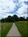
Cowpath, Kidbrooke Park
Linking the Michael Hall School with lewes Road, the A22. The path is permissive and allows access between the A22 and Priory Road.
Image: © Simon Carey
Taken: 12 Jun 2022
0.19 miles