IMAGES TAKEN NEAR TO
Nursery Lane, HAYWARDS HEATH, RH17 7RB
Introduction
This page details the photographs taken nearby to Nursery Lane, RH17 7RB by members of the Geograph project.
The Geograph project started in 2005 with the aim of publishing, organising and preserving representative images for every square kilometre of Great Britain, Ireland and the Isle of Man.

There are currently over 7.5m images from over14,400 individuals and you can help contribute to the project by visiting https://www.geograph.org.uk
Image Map
Images are licensed for reuse under creativecommons.org/licenses/by-sa/2.0
Notes
- Clicking on the map will re-center to the selected point.
- The higher the marker number, the further away the image location is from the centre of the postcode.
Image Listing (45 Images Found)
Images are licensed for reuse under creativecommons.org/licenses/by-sa/2.0
Image
Details
Distance
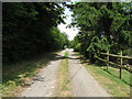
1
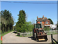
Strood Farm
Viewed from the bridleway that is called Nursery Lane. There has been a farm here since medieval times though the current farmhouse looks from this angle to date from the 19th century.
Image: © Simon Carey
Taken: 10 Apr 2011
0.01 miles
3
New Barn, Strood Farm
Recently built barn next to the footpath junction north of the farmhouse. There is another house being built beyond the barn out of sight to the left.
Image: © Simon Carey
Taken: 10 Apr 2011
0.02 miles
4
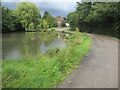
Pond adjacent to track
Public Bridleway Wivelsfield 12 to Strood Farm.
Image: © Peter Holmes
Taken: 14 Aug 2014
0.03 miles
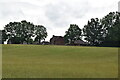
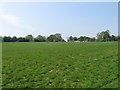
6
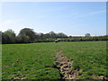
Strood Meadow
The name of the field according to Wivelsfield's 1843 tithe map that shares its name with another field to the north.
Image: © Simon Carey
Taken: 10 Apr 2011
0.04 miles
7
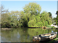
Pond, Strood Farm
Believed to date back to the medieval period as a source of water for nearby Strood Farm.
Image: © Simon Carey
Taken: 10 Apr 2011
0.04 miles
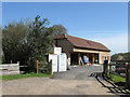
8
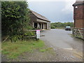
Warning to Trespassers
Barn and yard at Strood Farm.
Image: © Peter Holmes
Taken: 14 Aug 2014
0.04 miles
9
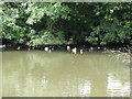
Ducks cooling off under the trees
Pond at Strood Farm
Image: © Dave Spicer
Taken: 4 Jul 2009
0.04 miles
10
Carthouse Field
The name of the field according to Wivelsfield's 1843 tithe map. The outbuilding in the distance belongs to Strood Farm.
Image: © Simon Carey
Taken: 24 Apr 2011
0.06 miles