IMAGES TAKEN NEAR TO
Hurstwood Close, HAYWARDS HEATH, RH17 7FU
Introduction
This page details the photographs taken nearby to Hurstwood Close, RH17 7FU by members of the Geograph project.
The Geograph project started in 2005 with the aim of publishing, organising and preserving representative images for every square kilometre of Great Britain, Ireland and the Isle of Man.

There are currently over 7.5m images from over14,400 individuals and you can help contribute to the project by visiting https://www.geograph.org.uk
Image Map (Loading...)


Getting Data...Please wait
Leaflet Map data © OpenStreetMap
Images are licensed for reuse under creativecommons.org/licenses/by-sa/2.0
Notes
- Clicking on the map will re-center to the selected point.
- The higher the marker number, the further away the image location is from the centre of the postcode.
Image Listing (55 Images Found)
Images are licensed for reuse under creativecommons.org/licenses/by-sa/2.0
Image
Details
Distance
1
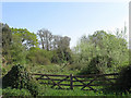
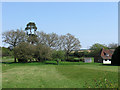
Garden Field
The name of the field according to Wivelsfield's 1843 tithe map of which this is now an overgrown remnant having lost the northern part to Image and the south piece to a house called Braydells.
Image: © Simon Carey
Taken: 20 Apr 2011
0.02 miles
2
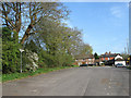
Hurstwood Lane
Minor road linking the B2112 to the A273 and therefore due to Image currently used as a rat run. The first house on the right contains Sunnyside and Bramble Dykes with Hurstwood Cottage beyond.
Image: © Simon Carey
Taken: 30 Apr 2011
0.05 miles
3
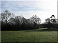
Jeffreys Green
Site of a former common that once existed at the junction of the B2112 and Hurstwood Lane. Gradual encroachment from the 17th century meant that only a small area of land at Image was left by 1800.
Image: © Simon Carey
Taken: 10 Apr 2011
0.05 miles
4
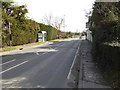
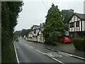
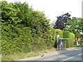
Fox Hill with bus stop at "Fox and Hounds" PH
This is in West Sussex.
Image: © Shazz
Taken: 28 Feb 2017
0.05 miles
5
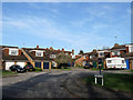
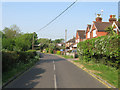
Houses, Hurstwood Lane, Fox Hill
Originally part of an old medieval common known as Jeffreys Green which was gradually encroached upon from the 16th century onwards so that by 1800 little was left. During the 1850s Tavistock House was built on the site facing Fox Hill, the B2112 which remained here until it was demolished in the early 1970s and this small estate of houses were built.
Image: © Simon Carey
Taken: 10 Apr 2011
0.06 miles
8
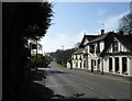
Fox and Hounds Inn, Fox Hill
Built on what was once a small common known as Jeffrey's Green probably in the 18th century when what is now the B2112 was turnpiked. A former toll booth existed at the end of the car park in the distance.
Image: © Simon Carey
Taken: 10 Apr 2011
0.07 miles
9
Converted Oast House, Cleavewaters Farm
Built as a square rather than the normal round tower found in Kent and Sussex now a house. The field behind was called Image whilst that on the opposite of Fox Hill, the B2112, was known as Image on Wivelsfield's 1843 tithe map.
Image: © Simon Carey
Taken: 20 Apr 2011
0.07 miles
10
Car Park, Fox and Hounds, Fox Hill
Originally part of a small common known as Jeffreys Green that surrounded an old crossroads; the old north-south droveway that is now the modern B2112, Hurstwood Lane heading east, and another route that is now just a footpath going west. The first named route was turnpiked in 1770 as part of a main London-Brighton route which I'm guessing would be the origins of the Fox and Hound at the far end. Also constructed in what is now the car park was a toll house known as Cleavewaters after the nearby farm and marked on the 1875 OS map. By the next edition in 1899 it had gone.
Image: © Simon Carey
Taken: 10 Apr 2011
0.08 miles