IMAGES TAKEN NEAR TO
Grainger Way, HAYWARDS HEATH, RH17 7DL
Introduction
This page details the photographs taken nearby to Grainger Way, RH17 7DL by members of the Geograph project.
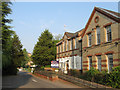
The Geograph project started in 2005 with the aim of publishing, organising and preserving representative images for every square kilometre of Great Britain, Ireland and the Isle of Man.

There are currently over 7.5m images from over14,400 individuals and you can help contribute to the project by visiting https://www.geograph.org.uk
Image Map
Images are licensed for reuse under creativecommons.org/licenses/by-sa/2.0
Notes
- Clicking on the map will re-center to the selected point.
- The higher the marker number, the further away the image location is from the centre of the postcode.
Image Listing (54 Images Found)
Images are licensed for reuse under creativecommons.org/licenses/by-sa/2.0
Image
Details
Distance
2
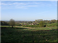
Twelve Acres
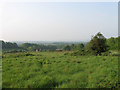
The name of the field according to Wivelsfield's 1843 tithe map viewed from Southdowns Park. The buildings below belong to Hospital Farm whilst the South Downs are just visible through the haze on the horizon. This field is earmarked for development and will have housing built upon as the Haywards Heath relief road is constructed to the south.
Image: © Simon Carey
Taken: 30 Apr 2011
0.05 miles
3
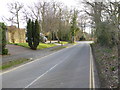
Country road
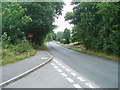
This is Hurstwood Lane, a bit of a 'rat run' and also used as overspill parking from the Princess Royal Hospital around the corner.
Image: © Nigel Freeman
Taken: 5 Jul 2005
0.07 miles
4
Old Farm Close
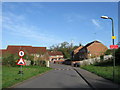
Small recently built estate constructed next to the Princess Royal Hospital. The long gap between Hurstwood Lane and the beginning of houses suggests it was built in the late 1990s as the plans for the Haywards Heath relief road, which will travel through that gap, were being formulated. Although originally part of Wivelsfield parish the land here was transferred in 1934 and is now part of Haywards Heath.
Image: © Simon Carey
Taken: 10 Apr 2011
0.07 miles
5
Martlet Lodge
Originally part of St Francis Hospital and used as an isolation unit. Currently awaiting redevelopment.
Image: © Simon Carey
Taken: 30 Apr 2011
0.10 miles
6
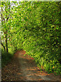
Old Track to Hospital Farm
The hospital was constructed on land once farmed by Hurst Farm and in time the former came to own the latter in order to provide both provisions and work for the patients, all part of the Victorian drive for self sufficiency. This remained the case until 1970 when the law was changed forbidding hospitals using patients for employment and the farm was eventually sold in 1978. The track is private and no longer seems well used.
Image: © Simon Carey
Taken: 30 Apr 2011
0.10 miles
8
Orchard Field
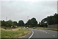
The name of the field according to Wivelsfield's 1843 tithe map whose days are numbered as the Haywards Heath relief road is due to built in the next few years. Its projected route will run from the right of Hospital Farm in the dip below and head straight through the point where I am standing joining the A272 at the current junction with Hurstwood Lane.
Image: © Simon Carey
Taken: 10 Apr 2011
0.11 miles
10
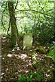
Sussex County Lunatic Asylum Burial Ground
The Asylum burial ground is now overgrown and derelict, it was full when it closed in 1891,but according to the plans held by the East Sussex Records Office, only four of the graves had a headstone. This photo shows one of the headstones still in situ.
Image: © Peter Jeffery
Taken: 1 Apr 2008
0.11 miles