IMAGES TAKEN NEAR TO
Birchgrove Road, HAYWARDS HEATH, RH17 7BS
Introduction
This page details the photographs taken nearby to Birchgrove Road, RH17 7BS by members of the Geograph project.
The Geograph project started in 2005 with the aim of publishing, organising and preserving representative images for every square kilometre of Great Britain, Ireland and the Isle of Man.

There are currently over 7.5m images from over14,400 individuals and you can help contribute to the project by visiting https://www.geograph.org.uk
Image Map
Images are licensed for reuse under creativecommons.org/licenses/by-sa/2.0
Notes
- Clicking on the map will re-center to the selected point.
- The higher the marker number, the further away the image location is from the centre of the postcode.
Image Listing (39 Images Found)
Images are licensed for reuse under creativecommons.org/licenses/by-sa/2.0
Image
Details
Distance
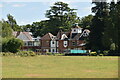
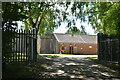
1
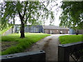
Westall House, Birchgrove Road
Currently a retirement home. Originally the site of Clarkes Farm which was rebuilt in the late 19th century. Since then the building has been known as Hazelwood and Keynes Place.
Image: © Simon Carey
Taken: 30 Aug 2020
0.02 miles
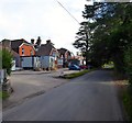
5
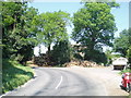
Corner into Birchgrove Road from Horsted Keynes
This bend is quite 'blind' and there are always logs stored in large piles.
Image: © Nigel Freeman
Taken: 14 Jul 2005
0.09 miles
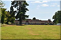
6
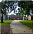
Horsted Keynes Service Reservoir
The covered reservoir is located to the east of the village in a former field called House Field according to Horsted Keynes' 1842 tithe map.
Image: © Simon Carey
Taken: 30 Aug 2020
0.10 miles
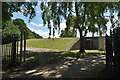
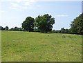
10
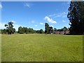
Horsted Meadow
The name of the field according to Horsted Keynes' 1842 tithe map with Westall House in the distance.
Image: © Simon Carey
Taken: 20 Aug 2020
0.10 miles