IMAGES TAKEN NEAR TO
Ridge Way, HAYWARDS HEATH, RH17 7AQ
Introduction
This page details the photographs taken nearby to Ridge Way, RH17 7AQ by members of the Geograph project.
The Geograph project started in 2005 with the aim of publishing, organising and preserving representative images for every square kilometre of Great Britain, Ireland and the Isle of Man.

There are currently over 7.5m images from over14,400 individuals and you can help contribute to the project by visiting https://www.geograph.org.uk
Image Map
Images are licensed for reuse under creativecommons.org/licenses/by-sa/2.0
Notes
- Clicking on the map will re-center to the selected point.
- The higher the marker number, the further away the image location is from the centre of the postcode.
Image Listing (25 Images Found)
Images are licensed for reuse under creativecommons.org/licenses/by-sa/2.0
Image
Details
Distance
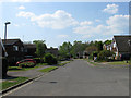
1
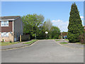
Ridge Way, Haywards Heath
A very small cul-de-sac off Image containing just two houses at the present though one wonders whether at some point in the future it will be extended into Image which lies immediately to the north. Built in the late initially in the parish Wivelsfield it was transferred over to Haywards Heath once completed.
Image: © Simon Carey
Taken: 20 Apr 2011
0.03 miles
2
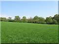
Little Lunces (2)
The name of the field according to Wivelsfield's 1843 tithe map that lies to the west of Image A new estate has been constructed at the end of the field.
Image: © Simon Carey
Taken: 20 Apr 2011
0.05 miles
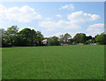
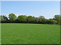
3
Great Lunces (3)
The name of the field according to Wivelsfield's 1843 tithe map with this section lying north of Image, north west of Image and west of Image The houses belong to Image and were built in the 1970s on afield called Four Acres. A wall was built in the foreground sometime in the late 19th century which is now overgrown.
Image: © Simon Carey
Taken: 20 Apr 2011
0.05 miles
4
Little Lunces (1)
The name of the field according to Wivelsfield's 1843 tithe map which is to the east of Image and has been extended to include Image and Image to the south. The houses in the distance face onto Lewes Road, the A272, and are in Haywards Heath.
Image: © Simon Carey
Taken: 20 Apr 2011
0.07 miles
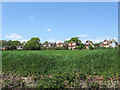
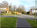
5
Greenhill Way, Haywards Heath
This section of the small estate was built in the late 1970s on a former field called Four Acres. Once part of Wivelsfield parish it was transferred over to Haywards Heath after the estate was built.
Image: © Simon Carey
Taken: 20 Apr 2011
0.07 miles
6
Great Lunces (4)
The name of the field according to Wivelsfield's 1843 tithe map that lies north of Image, north east of Image and east of Image This part of the field has been extended to include Image and Image to the immediate north.
Image: © Simon Carey
Taken: 20 Apr 2011
0.08 miles
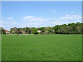
8
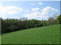
Great Lunces (2)
The name of the field according to Wivelsfield's 1843 tithe map that lies west of Image, south of Image and south west of Image Asylum Wood forms the backdrop.
Image: © Simon Carey
Taken: 20 Apr 2011
0.13 miles
9
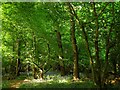
Colwell Shaw
The name of the wood according to Wivelsfield's 1843 tithe map that lies on the western side of Colwell Lane.
Image: © Simon Carey
Taken: 30 Apr 2011
0.14 miles
10
Great Lunces (1)
The name of the field according to Wivelsfield's 1843 tithe map that lies to the east of Image, south of Image and south east of Image
Image: © Simon Carey
Taken: 20 Apr 2011
0.16 miles