IMAGES TAKEN NEAR TO
Brighton Road, HAYWARDS HEATH, RH17 5SU
Introduction
This page details the photographs taken nearby to Brighton Road, RH17 5SU by members of the Geograph project.
The Geograph project started in 2005 with the aim of publishing, organising and preserving representative images for every square kilometre of Great Britain, Ireland and the Isle of Man.

There are currently over 7.5m images from over14,400 individuals and you can help contribute to the project by visiting https://www.geograph.org.uk
Image Map
Images are licensed for reuse under creativecommons.org/licenses/by-sa/2.0
Notes
- Clicking on the map will re-center to the selected point.
- The higher the marker number, the further away the image location is from the centre of the postcode.
Image Listing (26 Images Found)
Images are licensed for reuse under creativecommons.org/licenses/by-sa/2.0
Image
Details
Distance
1
Aniska Lodge
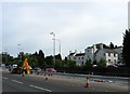
A substantial nursing home on the old Brighton Road that now overlooks the A23. Parts of the building date back to the 16th century but the house was extended in the 19th century and more recently when it converted to its current use. The building has had many names, it is marked as Pitts Head on Cuckfield's 1842 tithe map, Hazeldean on the 1879 OS map and by the early 20th century had become Old Haslings Hotel which it remained until the 1960s. After its closure it reopened a few later as Markwells Hotel until the 1980s when it became The Taverners, a restaurant and night club. When it became Aniska Lodge I've yet to find out. In the foreground the road widening works of the A23 are in progress.
Image: © Simon Carey
Taken: 25 Sep 2014
0.01 miles
2
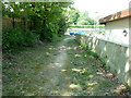
Footpath 15CR approaching service road
On the far side of the wooden fence is the new A23 and this side is a fragment of the old A23. The concrete wall is the boundary wall for a Care Home.
Image: © Dave Spicer
Taken: 23 Apr 2011
0.01 miles
3
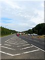
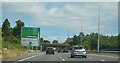
A23 (T)
Looking northwards towards Pitts Head Crossroads from the junction with northern slip road out of Bolney.
Image: © Simon Carey
Taken: 25 Sep 2014
0.05 miles
4
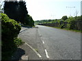
Section of the former A23
This short section is used as a service road for the houses on the left and terminates at the end of the fence.
Image: © Dave Spicer
Taken: 23 Apr 2011
0.05 miles
7
New Orchard
The name of the field according to Cuckfield's 1842 tithe map that lies to the west of a house called Clovelly, east of Image and south of Image
Image: © Simon Carey
Taken: 25 Sep 2014
0.11 miles
8
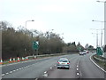
A23 South of Pitts Head Crossroads, between Warninglid and Cuckfield, West Sussex
Viewed from the flyover of the B2115 (Cuckfield Lane) at the crossroads, looking S. The A23 is a major N-S trunk road through West Sussex and is dual carriageway here (and for most of its length through the county).
Image: © Pete Chapman
Taken: 8 Oct 2005
0.11 miles
9
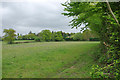
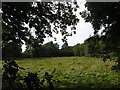
Field east of A23
Beyond are houses on Orchard Way.
Image: © Robin Webster
Taken: 16 May 2010
0.11 miles
10
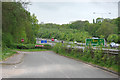
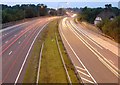
Old A23 and new A23
The old alignment comes to an end. It eventually continues some way along on the far side of the new alignment, where it is used as a slip road. The blue sign advises that unmarked police cars are operating. This is no idle threat, and they have used some unlikely makes such as Subaru.
Image: © Robin Webster
Taken: 16 May 2010
0.12 miles