IMAGES TAKEN NEAR TO
Foxhole Lane, HAYWARDS HEATH, RH17 5RT
Introduction
This page details the photographs taken nearby to Foxhole Lane, RH17 5RT by members of the Geograph project.
The Geograph project started in 2005 with the aim of publishing, organising and preserving representative images for every square kilometre of Great Britain, Ireland and the Isle of Man.

There are currently over 7.5m images from over14,400 individuals and you can help contribute to the project by visiting https://www.geograph.org.uk
Image Map
Images are licensed for reuse under creativecommons.org/licenses/by-sa/2.0
Notes
- Clicking on the map will re-center to the selected point.
- The higher the marker number, the further away the image location is from the centre of the postcode.
Image Listing (34 Images Found)
Images are licensed for reuse under creativecommons.org/licenses/by-sa/2.0
Image
Details
Distance
1
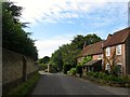
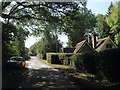
Bolney Cottages, Foxhole Lane
Located just to the north of Image whose entrance gates can be seen on the left. They date back to the 18th century and was known as Wynn's Cottage on the 1874 OS map and later Bolney Lodge Cottage prior to becoming Bolney Cottages. The building also seems to have been a single and later two residences.
Image: © Simon Carey
Taken: 31 Aug 2014
0.00 miles
2
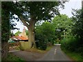
Lodge Lane
Minor country lane that runs between The Street and the point where Foxhole Lane becomes Cross Colwood Lane. The building on the left is Bolney Lodge Mews.
Image: © Simon Carey
Taken: 31 Aug 2014
0.02 miles
3
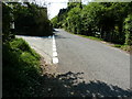
Lane junction on the west side of Bolney
The resurfaced road changes from Foxhole Lane to Cross Colwood Lane at this junction with Lodge Lane on the left.
Image: © Dave Spicer
Taken: 23 Apr 2011
0.03 miles
4
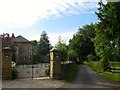
Bolney Lodge, Foxhole Lane
The house dates from the 18th century with later 19th century additions and was a reputed stopping place for the Prince Regent on his many trips to Brighton.
Image: © Simon Carey
Taken: 31 Aug 2014
0.03 miles
5
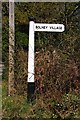
Old Direction Sign - Signpost by Nailard's Wood, Bolney parish
Black iron cap finial - 1 arm; East Sussex wood by the UC road, in parish of Bolney (Mid Sussex District), Cross Colwood Lane junction with Foxhole Lane, on verge at junction with Lodge Lane.
Surveyed
Milestone Society National ID: SX_TQ2523A
Image: © Milestone Society
Taken: Unknown
0.03 miles
6
East Lodge, Cross Colwood Lane
Located to the north of Image and dating from the 19th century. To the left is the junction with Lodge Lane where Cross Colwood Lane becomes Foxhole Lane.
Image: © Simon Carey
Taken: 25 Sep 2014
0.03 miles
7
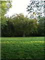
The Pasture
The name of the field according to Bolney's 1842 tithe map that appears to have been cut out of Naillard's Wood and lies to the rear of East Lodge on Cross Colwood Lane.
Image: © Simon Carey
Taken: 25 Sep 2014
0.06 miles
8
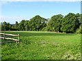
The Mead
The name of the field according to Bolney's 1842 tithe map that lies to the west of Image, south of Image and north of Image
Image: © Simon Carey
Taken: 31 Aug 2014
0.09 miles
9
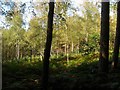
Naillards Wood
A view of the eastern end of the wood adjacent to Cross Colwood Lane where birch seems to be in abundance.
Image: © Simon Carey
Taken: 25 Sep 2014
0.10 miles
10
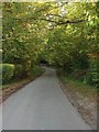
Cross Colwood Lane
Heading north from the junction with Lodge Lane as a continuation of Foxhole Lane. The highway then turns west and meanders its way to another junction with Spronkett's Lane.
Image: © Simon Carey
Taken: 25 Sep 2014
0.11 miles