IMAGES TAKEN NEAR TO
Pickwell Lane, HAYWARDS HEATH, RH17 5RH
Introduction
This page details the photographs taken nearby to Pickwell Lane, RH17 5RH by members of the Geograph project.
The Geograph project started in 2005 with the aim of publishing, organising and preserving representative images for every square kilometre of Great Britain, Ireland and the Isle of Man.

There are currently over 7.5m images from over14,400 individuals and you can help contribute to the project by visiting https://www.geograph.org.uk
Image Map
Images are licensed for reuse under creativecommons.org/licenses/by-sa/2.0
Notes
- Clicking on the map will re-center to the selected point.
- The higher the marker number, the further away the image location is from the centre of the postcode.
Image Listing (38 Images Found)
Images are licensed for reuse under creativecommons.org/licenses/by-sa/2.0
Image
Details
Distance
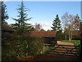
1
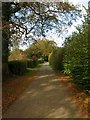
Pickwell Lane
Heading northwards towards Hormanshoad Farm. The lane, an old droveway, runs from the A272 in the south to Broxmead Lane to the north
Image: © Simon Carey
Taken: 28 Oct 2014
0.01 miles
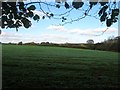
2
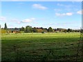
Great Mead
The name of the field according to Cuckfield's 1843 tithe map that is bounded by Pickwell Lane to the south, Broxmead Lane to the north, Image to the west and Windmill Field and Image to the east.
Image: © Simon Carey
Taken: 28 Oct 2014
0.04 miles
3
Pickwell Lane and bales
What do they keep in those light green bales? Hay? Silage? The wooden post marks the start of a bridleway short cut to Broxmead Lane which, in view of its slope and condition, is not worth taking by bicycle, or on foot in winter.
Image: © Robin Webster
Taken: 3 Apr 2010
0.06 miles
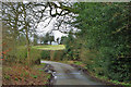
4
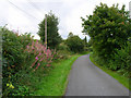
Broxmead Lane
Anybody know what those pink plants are by the roadside? The lane connects Bolney with Slough Green.
Image: © Simon Carey
Taken: 26 Aug 2006
0.06 miles
5
Millfield Barn, Pickwell Lane
A converted barn now a residence. The barn was previously known as Noah's Ark until at least the 1962 OS map after which it becomes Millfields Farm. The name Millfields comes from a house to the north that fronts onto Broxmead Lane though a field to the south is also called Windmill Field which may suggest a site of a former mill or fields owned by a local miller. However, there was nothing marked on the 1843 tithe map nor the 1813 OS map.
Image: © Simon Carey
Taken: 28 Oct 2014
0.06 miles
6
Middle Field/Little Field
The name of the fields according to Cuckfield's 1843 tithe map that have been merged to form a larger unit. Middle Field was to the north west adjacent to Broxmead Lane whilst Little Field was in the foreground next to Image To the south is Windmill Field whilst to the north is Image
Image: © Simon Carey
Taken: 28 Oct 2014
0.10 miles
7
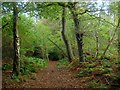
Bridleway to Broxmead Lane
An old Barnetts estate map from the late 1960s has this bridleway down as West Street though I've not seen a reference to this elsewhere. An early OS map has West Street as the name of a settlement near the junction of this bridleway and Broxmead Lane, whilst the 1843 Cuckfield tithe map has an adjacent field called Wish Street Field a little to the north. By the 1897 OS map the name has been shifted westwards and seems to refer to the houses along the section of Broxmead Lane as it runs westwards towards the parish boundary with Bolney. By the 1937 edition the name has disappeared from the map altogether. The bridleway itself separates open fields to the west, Windmill Field, Image and Image respectively, with Long Wood to the east.
Image: © Simon Carey
Taken: 28 Oct 2014
0.12 miles
8
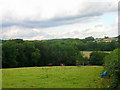
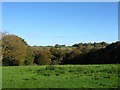
High Weald near Bolney
Epitomises the landscape in this part of Sussex, fields and woodland intermingling on the slopes and valleys. The woodland on the slopes of the hill is The Hanger whilst Broxmead Farm is just out of picture to the right of the arable fields.
Image: © Simon Carey
Taken: 26 Aug 2006
0.12 miles
9
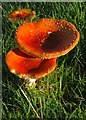
Fly Agaric (Amanita muscaria)
These distinct mushrooms were found sheltering under a lone tree at the southern end of Image During the medieval period they would be crushed and soaked in milk in order to attract then kill flies. If you look closely the morning dew is still visible on the grass.
Image: © Simon Carey
Taken: 28 Oct 2014
0.12 miles
10
Wood Field
The name of the field according to Cuckfield's 1843 tithe map that is bounded by Broxmead Lane to the south and Image to the east.
Image: © Simon Carey
Taken: 28 Oct 2014
0.12 miles