IMAGES TAKEN NEAR TO
London Road, HAYWARDS HEATH, RH17 5PX
Introduction
This page details the photographs taken nearby to London Road, RH17 5PX by members of the Geograph project.
The Geograph project started in 2005 with the aim of publishing, organising and preserving representative images for every square kilometre of Great Britain, Ireland and the Isle of Man.

There are currently over 7.5m images from over14,400 individuals and you can help contribute to the project by visiting https://www.geograph.org.uk
Image Map
Images are licensed for reuse under creativecommons.org/licenses/by-sa/2.0
Notes
- Clicking on the map will re-center to the selected point.
- The higher the marker number, the further away the image location is from the centre of the postcode.
Image Listing (39 Images Found)
Images are licensed for reuse under creativecommons.org/licenses/by-sa/2.0
Image
Details
Distance
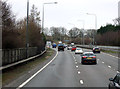
1
I name this ship Ivy
By the side of private road near A23 underpass
Image: © Dave Spicer
Taken: 20 Jun 2009
0.01 miles
2
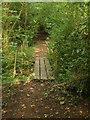
Footbridge, Bolney Wood
Taking the High Weald Landscape Trail over an unnamed stream as it runs between Bolney and Buncton Lane.
Image: © Simon Carey
Taken: 7 Sep 2014
0.04 miles
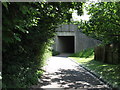
3
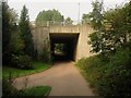
Bridge under the A23
Built when the A23 was realigned in the early 1990s to enable access for Woodside Cottages to London Road. Also making use it of it is the High Weald Landscape Trail which follows the drive to the fork before heading into Bolney Wood.
Image: © Simon Carey
Taken: 7 Sep 2014
0.05 miles
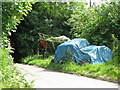
4
Lean-to shed found alongside footpath in Bolney Wood
Image: © Dave Spicer
Taken: 20 Jun 2009
0.05 miles
6
Looking east on the High Weald Landscape Trail towards bridge under the A 23 at Bolney
Image: © Dave Spicer
Taken: 20 Jun 2009
0.06 miles
7
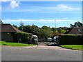
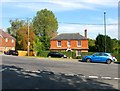
Highlands Farm Business Park, London Road, Bolney
Former barns belonging to The Highlands that have been converted into small business units since they were separated by the rerouting of the A23.
Image: © Simon Carey
Taken: 5 Oct 2014
0.06 miles
8
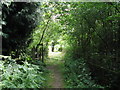
This footpath runs parallel with the A23 at Bolney
The waymarker takes the High Weald Landscape Trail through Bolney Wood to Bunctoncourt on Buncton Lane
Image: © Dave Spicer
Taken: 20 Jun 2009
0.07 miles
9
Chantry House, London Road, Bolney
Viewed from the junction with Ryecroft Road the house is the former Queen's Head Inn which was the original staging post when the London-Brighton turnpike was built, Image to the north has only been a pub since the 1960s and was a former farm. The inn still served travellers down the A23 over the years and was a popular vantage point for the annual London-Brighton veteran car run. In the early 1990s the A23 was rerouted to the east and the old route became a backwater and the pub eventually closed in 2000 and has now been converted into a private dwelling.
Image: © Simon Carey
Taken: 19 Sep 2014
0.08 miles
10
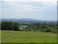
Hillside view across the busy A23 towards the South Downs
Image: © Dave Spicer
Taken: 20 Jun 2009
0.08 miles