IMAGES TAKEN NEAR TO
Cherry Lane, HAYWARDS HEATH, RH17 5JW
Introduction
This page details the photographs taken nearby to Cherry Lane, RH17 5JW by members of the Geograph project.
The Geograph project started in 2005 with the aim of publishing, organising and preserving representative images for every square kilometre of Great Britain, Ireland and the Isle of Man.

There are currently over 7.5m images from over14,400 individuals and you can help contribute to the project by visiting https://www.geograph.org.uk
Image Map
Images are licensed for reuse under creativecommons.org/licenses/by-sa/2.0
Notes
- Clicking on the map will re-center to the selected point.
- The higher the marker number, the further away the image location is from the centre of the postcode.
Image Listing (28 Images Found)
Images are licensed for reuse under creativecommons.org/licenses/by-sa/2.0
Image
Details
Distance
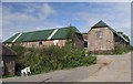
1
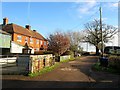
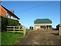
Sidnye Farm Cottages
A pair of cottages on the eastern side of Sidnye Farm built between the wars. The track is the main drive to Cherry Lane.
Image: © Simon Carey
Taken: 20 Dec 2014
0.01 miles
2
Sidnye Farm cottages
The farm is located 2.5 miles north of Haywards Heath
Image: © Paul Gillett
Taken: 22 Jul 2010
0.02 miles
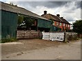
3
Track towards Sidnye Farm
In the dip ahead is a hardcore dump and assorted machinery.
Image: © Robin Webster
Taken: 3 Jun 2010
0.05 miles
4
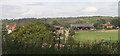
Sidnye Farm
Located on a ridge to the south of the Lower Ouse valley. The farmhouse is on the left, see Image, whilst Image are beyond the barns to the right. The farm belongs to the Borde Hill Estate.
Image: © Simon Carey
Taken: 20 Dec 2014
0.05 miles
5
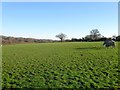
Balcombe Mead (2)
The name of the field according to Cuckfield's 1843 tithe map that has now been split into two sections, this one on the ridge to the north of Sidnye Farm and another beyond the fence to the left that lies on a slope that heads down to the River Ouse, see Image To the west beyond the footpath is Image
Image: © Simon Carey
Taken: 6 Dec 2014
0.05 miles
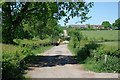
7
Sidnye Farm
Located on top of a ridge to the south of the Ouse valley. Farmhouse looks 18th or 19th century though a farm has been recorded here since at least the 14th.
Image: © Simon Carey
Taken: 6 Dec 2014
0.08 miles
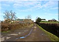
9
Farm buildings on Sidnye Farm
Seen from footpath 35aCR.
Image: © Andy Potter
Taken: 20 Sep 2006
0.08 miles
10
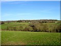
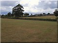
Nine Acres
The name of the field according to Cuckfield's 1843 tithe map that is bounded by Image to the west, Image to the east and the River Ouse to the north at the foot of the slope. Visible in the distance are The White House to the left and Spicer's Farm to the right with Coombehole Wood between the two.
Image: © Simon Carey
Taken: 20 Dec 2014
0.08 miles