IMAGES TAKEN NEAR TO
Cleavers Lane, HAYWARDS HEATH, RH17 5HZ
Introduction
This page details the photographs taken nearby to Cleavers Lane, RH17 5HZ by members of the Geograph project.
The Geograph project started in 2005 with the aim of publishing, organising and preserving representative images for every square kilometre of Great Britain, Ireland and the Isle of Man.

There are currently over 7.5m images from over14,400 individuals and you can help contribute to the project by visiting https://www.geograph.org.uk
Image Map
Images are licensed for reuse under creativecommons.org/licenses/by-sa/2.0
Notes
- Clicking on the map will re-center to the selected point.
- The higher the marker number, the further away the image location is from the centre of the postcode.
Image Listing (33 Images Found)
Images are licensed for reuse under creativecommons.org/licenses/by-sa/2.0
Image
Details
Distance
2
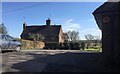
Cleavers Cottages
Originally a farmhouse dating from the 17th century but now split into two cottages. Viewed from Cleaver's Lane.
Image: © Simon Carey
Taken: 20 Dec 2014
0.01 miles
3
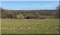
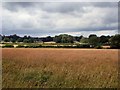
Ricksteddle Mead
The name of the field according to Cuckfield's 1843 tithe map that is bounded by Image to the north and Image to the west. Lowlands Wood is visible in the distance.
Image: © Simon Carey
Taken: 20 Dec 2014
0.03 miles
4
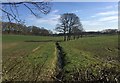
Stream at Cleaver?s Lane
A small stream heading eastwards from Cleaver’s Lane.
Image: © Chris Thomas-Atkin
Taken: 26 Mar 2018
0.05 miles
5
Cleaver?s Barn
Cleaver’s Barn viewed from the public footpath.
Image: © Chris Thomas-Atkin
Taken: 26 Mar 2018
0.05 miles
6
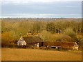
Cleaver's Barn
A former timbered barn dating back to the 18th century that has now been converted into a residence.
Image: © Simon Carey
Taken: 20 Dec 2014
0.06 miles
7
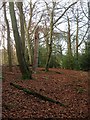
Toll House
The name of the wood according to Cuckfield's 1843 tithe map though no OS maps give the wood a title. Located to the north of Image, east of Image and west of Cleaver's Lane.
Image: © Simon Carey
Taken: 20 Dec 2014
0.06 miles
8
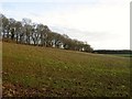
Further Mead/Kemps Field
The name of the fields according to Cuckfield's 1843 tithe map that have been merged to form a larger unit. Further mead was in the foreground adjacent to Cleaver's Lane whilst Kemps Field was on the far side. To the south is Image whilst in the distance is Lowlands Wood.
Image: © Simon Carey
Taken: 20 Dec 2014
0.07 miles
9
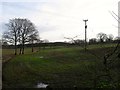
Farms near Cleavers Cottages
North of Cuckfield
Image: © Paul Gillett
Taken: 22 Jul 2010
0.09 miles
10
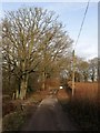
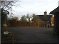
Cleaver's Lane
The gate marks the end of the public highway and the private drive to Bigges Farm. Interestingly both 1874 and 1897 OS maps have the lane continuing westwards along the bridleway towards Cuckfield Road, there is even a tollhouse at the junction on the earlier map.
Image: © Simon Carey
Taken: 20 Dec 2014
0.09 miles