IMAGES TAKEN NEAR TO
Staplefield Road, HAYWARDS HEATH, RH17 5HY
Introduction
This page details the photographs taken nearby to Staplefield Road, RH17 5HY by members of the Geograph project.
The Geograph project started in 2005 with the aim of publishing, organising and preserving representative images for every square kilometre of Great Britain, Ireland and the Isle of Man.

There are currently over 7.5m images from over14,400 individuals and you can help contribute to the project by visiting https://www.geograph.org.uk
Image Map
Images are licensed for reuse under creativecommons.org/licenses/by-sa/2.0
Notes
- Clicking on the map will re-center to the selected point.
- The higher the marker number, the further away the image location is from the centre of the postcode.
Image Listing (20 Images Found)
Images are licensed for reuse under creativecommons.org/licenses/by-sa/2.0
Image
Details
Distance
1
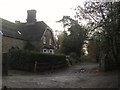
North Lodge/Weald Chase Cottage, Staplefield Road
Built sometime in the 19th century possibly as a lodge for Henmead Hall now divided into two properties. The adjacent track contains the public footpath which heads to Cuckfield High Street.
Image: © Simon Carey
Taken: 29 Nov 2014
0.04 miles
2
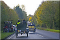
Staplefield Road (B2115) near Cuckfield
A Renault 2 seater is overtaken by a Humberette 2 seater on the Staplefield Road near Cuckfield.
Image: © Christine Matthews
Taken: 2 Nov 2008
0.05 miles
3
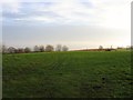
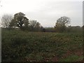
Great Beech Field/Little Beech Field
The name of the fields according to Cuckfield's 1843 tithe map that have been merged to form a larger unit. Great Beech Field was located to the west adjacent to Cleaver's Lane with Little Beech Field to the east next to Sparks Farm. To the south is Staplefield Road, the B2115.
Image: © Simon Carey
Taken: 29 Nov 2014
0.06 miles
4
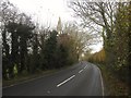
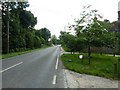
Staplefield Road
The B2115 which currently links Whitemans Green in Cuckfield to Plummers Plain east of Lower Beeding. The road is old and runs along a ridge and from the 1770s became part of the main London-Brighton coaching road until superseded by a new one constructed in 1816 that later became the A23.
Image: © Simon Carey
Taken: 29 Nov 2014
0.10 miles
5
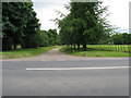
B2115 Staplefield Road east to Whitemans Green
Image: © Dave Spicer
Taken: 10 Jul 2011
0.11 miles
6
Site of Landgate Barn
Marked on Cuckfield's 1843 tithe map but not the 1874 OS map. Located to the north of Image
Image: © Simon Carey
Taken: 29 Nov 2014
0.13 miles
7
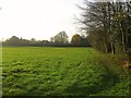
Beech Mead
The name of the field according to Cuckfield's 1843 tithe map viewed from Staplefield Road with Old Beech Farm at the southern end of the field.
Image: © Simon Carey
Taken: 29 Nov 2014
0.14 miles
8
Cleaver's Lane reaches Staplefield Road
A participant in the London to Brighton Veteran Car Run shows White Van Man how to do it.
Image: © Shazz
Taken: 6 Nov 2016
0.16 miles
9
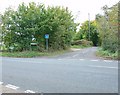
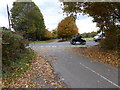
Junction of Cleavers Lane and Staplefield Road, Near Slough Green, West Sussex
Cleavers Lane is designated as a no through road (to motor vehicles). It provides access to Mizbrook's Farm (see Image) and Bigges Farm. The road junction is not marked with a finger post off the main road. View taken from the S, looking N, with Cleavers Lane straight ahead. The B2115 (Staplefield Road) goes to Cuckfield (right), and Staplefield, via Slough Green, to the Left.
Image: © Pete Chapman
Taken: 21 Oct 2005
0.16 miles
10
Private road to Henmead and Old Beech Farm
Image: © Dave Spicer
Taken: 20 Jun 2009
0.17 miles