IMAGES TAKEN NEAR TO
Cuckfield Road, HAYWARDS HEATH, RH17 5AG
Introduction
This page details the photographs taken nearby to Cuckfield Road, RH17 5AG by members of the Geograph project.
The Geograph project started in 2005 with the aim of publishing, organising and preserving representative images for every square kilometre of Great Britain, Ireland and the Isle of Man.

There are currently over 7.5m images from over14,400 individuals and you can help contribute to the project by visiting https://www.geograph.org.uk
Image Map
Images are licensed for reuse under creativecommons.org/licenses/by-sa/2.0
Notes
- Clicking on the map will re-center to the selected point.
- The higher the marker number, the further away the image location is from the centre of the postcode.
Image Listing (56 Images Found)
Images are licensed for reuse under creativecommons.org/licenses/by-sa/2.0
Image
Details
Distance
1
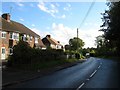
Cuckfield Road, Ansty
The B2036 heading south to Burgess Hill. The houses on the left were built not long after the Second World War.
Image: © Simon Carey
Taken: 11 Oct 2014
0.02 miles
2
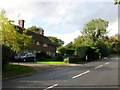
North Cottages, Cuckfield Road, Ansty
A pair of 19th century cottages located, rather confusingly, to the south of the village crossroads, and one of only two buildings on the western side of the B2035.
Image: © Simon Carey
Taken: 11 Oct 2014
0.03 miles
3
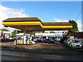
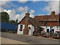
Ansty Service Station, Cuckfield Road, Ansty
Containing a small convenience store, the last device left in the small village. Beyond is a Suzuki dealership built on the site of a former nursery.
Image: © Simon Carey
Taken: 11 Oct 2014
0.05 miles
4
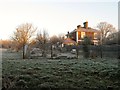
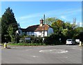
Challoners, Cuckfield Road, Ansty
Large 19th century detached villa on the eastern side of the B2036 with this view from the footpath to the south.
Image: © Simon Carey
Taken: 30 Dec 2014
0.06 miles
5
Ansty Cross Public House
Website: http://www.anstycross.co.uk/
Image: © Paul Gillett
Taken: 22 Jul 2010
0.06 miles
6
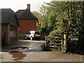
The Old Cottage, Cuckfield Road, Ansty
Located at the junction of the A272 and B2035 and dating back to the 16th century.
Image: © Simon Carey
Taken: 5 Oct 2014
0.07 miles
7
The Ancient Farm, Bolney Road, Ansty
Located at the village crossroads and believed to date back to the 15th century. Up to the Second World War it was known as Crouchfields or Crouchlands Farm.
Image: © Simon Carey
Taken: 11 Oct 2014
0.07 miles
8
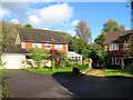
Mount Noddy, Ansty
Small cul de sac off Cuckfield Road containing three dwellings built sometime during the 1970s. Named after the old cottage to the immediate south.
Image: © Simon Carey
Taken: 11 Oct 2014
0.07 miles
9
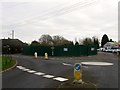
Ansty Cross Inn (Demolished)
The former pub had a precarious existence during the 1990s having closed then reopened due to lack of patronage before succumbing again in 2011 this time for good as the building was demolished in November 2014. The developers have agreed to place the distinctive green cross that fronted the former pub on any new building as a memorial.
See Image for when open, and Image after closure and pre-demolition.
Image: © Simon Carey
Taken: 30 Dec 2014
0.07 miles
10
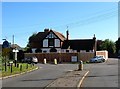
Ansty Cross Inn, Cuckfield Road, Ansty
For many years the Green Cross Inn before becoming the Ansty Cross, the old name of the village built around a crossroads. The pub shut in the late 1990s but reopened but has been closed since 2011 due to lack of patronage. The fencing around the premises suggests redevelopment is imminent.
Image: © Simon Carey
Taken: 5 Oct 2014
0.07 miles