IMAGES TAKEN NEAR TO
Garibaldi Road, REDHILL, RH1 6PB
Introduction
This page details the photographs taken nearby to Garibaldi Road, RH1 6PB by members of the Geograph project.
The Geograph project started in 2005 with the aim of publishing, organising and preserving representative images for every square kilometre of Great Britain, Ireland and the Isle of Man.

There are currently over 7.5m images from over14,400 individuals and you can help contribute to the project by visiting https://www.geograph.org.uk
Image Map
Images are licensed for reuse under creativecommons.org/licenses/by-sa/2.0
Notes
- Clicking on the map will re-center to the selected point.
- The higher the marker number, the further away the image location is from the centre of the postcode.
Image Listing (109 Images Found)
Images are licensed for reuse under creativecommons.org/licenses/by-sa/2.0
Image
Details
Distance
1
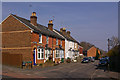
Garibaldi Road
This road presumably originally dates from the 1870s/1880s, given its name (Giuseppe Garibaldi, the Italian politician and military figure, died in 1882).
Image: © Ian Capper
Taken: 21 Mar 2009
0.03 miles
2
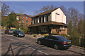
The Garibaldi
Presumably named after Giuseppe Garibaldi, the Italian politician and military figure, who died in 1882, which also presumably approximately dates the pub.
Image: © Ian Capper
Taken: 21 Mar 2009
0.04 miles
3
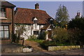
The Old Cottage
The oldest building in Redhill, dating from the first part of the 15th century when Mill Street was a country lane leading out of Reigate. It is grade II listed - for listing particulars see www.historicengland.org.uk/listing/the-list/list-entry/1294561.
Image: © Ian Capper
Taken: 21 Mar 2009
0.04 miles
4
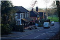
The Garibaldi, Redhill Common, Surrey
Situated on Mill Street, at the edge of Redhill Common.
Image: © Peter Trimming
Taken: 14 Jan 2012
0.05 miles
5
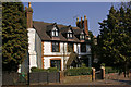
Old Garlands
Grade II listed house in Mill Street, dating from the 17th century. For listing particulars see www.historicengland.org.uk/listing/the-list/list-entry/1029094.
Image: © Ian Capper
Taken: 21 Mar 2009
0.07 miles
6
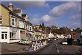
Garlands Road
Named after Garlands, a house nearby. The 1895 Godfrey edition map of Redhill shows the eastern side fully developed by then, but only the southern end of the western side.
Image: © Ian Capper
Taken: 8 Mar 2009
0.08 miles
7
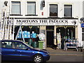
Mortons The Padlock, Ironmongers,Redhill
141-143 Brighton Road, Redhill, RH1 6PS. A good ironmongers shop.
Image: © Rib
Taken: 20 May 2008
0.08 miles
8
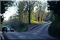
Road Junction on Redhill Common, Surrey
Mill Street continues, down the hill, whilst Sandpit Road peels off to the right.
Image: © Peter Trimming
Taken: 14 Jan 2012
0.08 miles
9
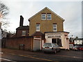
Domestic Appliance Service Centre on Mill Street
Image: © David Howard
Taken: 31 Jan 2016
0.09 miles
10
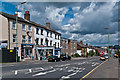
Brighton Road
Looking down Brighton Road towards central Redhill.
Image: © Ian Capper
Taken: 22 Apr 2012
0.09 miles