IMAGES TAKEN NEAR TO
Arbutus Road, REDHILL, RH1 6LJ
Introduction
This page details the photographs taken nearby to Arbutus Road, RH1 6LJ by members of the Geograph project.
The Geograph project started in 2005 with the aim of publishing, organising and preserving representative images for every square kilometre of Great Britain, Ireland and the Isle of Man.

There are currently over 7.5m images from over14,400 individuals and you can help contribute to the project by visiting https://www.geograph.org.uk
Image Map
Images are licensed for reuse under creativecommons.org/licenses/by-sa/2.0
Notes
- Clicking on the map will re-center to the selected point.
- The higher the marker number, the further away the image location is from the centre of the postcode.
Image Listing (78 Images Found)
Images are licensed for reuse under creativecommons.org/licenses/by-sa/2.0
Image
Details
Distance
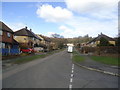
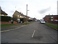
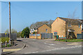
2
Arbutus Road
Road in the large housing development between Woodhatch and Meadvale dating mainly from the c.1950s, all with tree names.
Image: © Ian Capper
Taken: 19 Apr 2021
0.02 miles
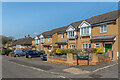
3
Arbutus Road
Road in the large housing development between Woodhatch and Meadvale dating mainly from the c.1950s, all with tree names. The building left of centre is a later addition, begin part of a redevelopment of garages in c.2000 with the building partly visible on the far left being a similar development, dating from c.2018.
Image: © Ian Capper
Taken: 19 Apr 2021
0.03 miles
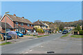
4
Greystones Close
c.1950s cul-de-sac of retirement bungalows off Hardwick Road, built on land to the rear of Greystone House which served as a children's home, marked as such on maps from the early 20th Century, but redeveloped c.2000 (see Image).
Image: © Ian Capper
Taken: 19 Apr 2021
0.03 miles
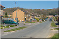
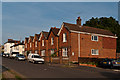
6
25 - 27a Hardwick Road
Two pairs of semi-detached houses built c.2000, replacing an earlier building, Greystone House, which served as a children's home, being marked as such on maps from the early 20th Century. The houses beyond are c.1950s when Hardwick Road, previously a cul-de-sac, was extended to meet the newly built Arbutus Road.
Hardwick Road was shown with that name on the 1896 1:2500 map, but Hardwicke Road on the 1913-4 and 1935 editions before reverting to its current name in the 1962-3 version, presumably to avoid confusion with Hardwicke Road in Reigate (see Image). the houses
Image: © Ian Capper
Taken: 19 Apr 2021
0.05 miles
7
Hardwick Road
Unusual row of detached houses in Hardwick Road, built around the turn of the 19th/20th century. The large white house in the background is locally listed, as is the first one beyond the main row. The road was shown as Hardwick Road on the 1896 1:2500 map, but Hardwicke Road on the 1913-4 and 1935 editions before reverting to it current name in the 1962-3 version, presumably to avoid confusion with Hardwicke Road in Reigate (see Image).
Image: © Ian Capper
Taken: 2 Jun 2011
0.05 miles
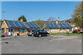
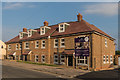
8
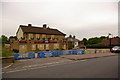
The Ship Inn
There was a pub here before 1869. The present building was built in 1952, set further back from the road to give parking space. It is now due to be demolished.
Image: © Ian Capper
Taken: 27 May 2008
0.05 miles
9
Box Tree Walk
c.2000 cul-de-sac off Arbutus Road.
Image: © Ian Capper
Taken: 19 Apr 2021
0.06 miles
10
Victory Court
Block of 12 flats in Copse Road, built on the site of the Ship Inn (see Image).
Image: © Ian Capper
Taken: 31 Jul 2014
0.06 miles