IMAGES TAKEN NEAR TO
Ridgemount Way, REDHILL, RH1 6JT
Introduction
This page details the photographs taken nearby to Ridgemount Way, RH1 6JT by members of the Geograph project.
The Geograph project started in 2005 with the aim of publishing, organising and preserving representative images for every square kilometre of Great Britain, Ireland and the Isle of Man.

There are currently over 7.5m images from over14,400 individuals and you can help contribute to the project by visiting https://www.geograph.org.uk
Image Map
Images are licensed for reuse under creativecommons.org/licenses/by-sa/2.0
Notes
- Clicking on the map will re-center to the selected point.
- The higher the marker number, the further away the image location is from the centre of the postcode.
Image Listing (102 Images Found)
Images are licensed for reuse under creativecommons.org/licenses/by-sa/2.0
Image
Details
Distance
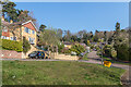
1
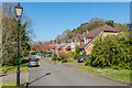
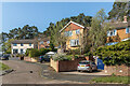
Ridgemount Way
Cul-de-sac off Pendleton Road completed in c.1997 on the site of a large Victorian house named Earlswood Mount which in its later years had been used for accommodation and offices by the nearby Redhill General Hospital.
Image: © Ian Capper
Taken: 19 Apr 2021
0.02 miles
2
Ridgemount Way
Cul-de-sac off Pendleton Road completed in c.1997 on the site of a large Victorian house named Earlswood Mount which in its later years had been used for accommodation and offices by the nearby Redhill General Hospital.
Image: © Ian Capper
Taken: 19 Apr 2021
0.04 miles
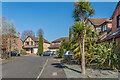
3
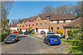
Cotland Acres
Cul-de-sac off Pendleton Road completed in c.1995.
Image: © Ian Capper
Taken: 19 Apr 2021
0.05 miles
4
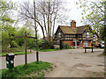
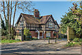
The Lodge, Ridgemount Way, Redhill
Formerly the lodge for the big house of Earlswood Mount, now no longer, and whose grounds have been built over.
Image: © Robin Webster
Taken: 21 Apr 2018
0.05 miles
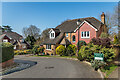
5
2 Ridgemount Way
House at entrance to Ridgemount Way, formerly the lodge to Earlswood Mount.
Image: © Ian Capper
Taken: 19 Apr 2021
0.06 miles
6
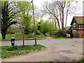
Path crossing of Mount View Drive, Redhill
This is common land. Redhill and Earlswood Commons are continuous, but between them in places such as here, the land is more in the nature of very large road verges.
Image: © Robin Webster
Taken: 21 Apr 2018
0.06 miles
7
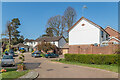
Fairlawn Drive
Cul-de-sac off Pendleton Road developed in the c.1950s/60s.
Image: © Ian Capper
Taken: 19 Apr 2021
0.07 miles
8
Mount Rise
Cul-de-sac off Cotland Acres completed in c.1995.
Image: © Ian Capper
Taken: 19 Apr 2021
0.07 miles
9
Fairlawn Drive
Cul-de-sac off Pendleton Road developed in the c.1950s/60s.
Image: © Ian Capper
Taken: 19 Apr 2021
0.07 miles
10
Cotland Acres
Cul-de-sac off Pendleton Road completed in c.1995.
Image: © Ian Capper
Taken: 19 Apr 2021
0.08 miles