IMAGES TAKEN NEAR TO
Station Approach East, REDHILL, RH1 6JH
Introduction
This page details the photographs taken nearby to Station Approach East, RH1 6JH by members of the Geograph project.
The Geograph project started in 2005 with the aim of publishing, organising and preserving representative images for every square kilometre of Great Britain, Ireland and the Isle of Man.

There are currently over 7.5m images from over14,400 individuals and you can help contribute to the project by visiting https://www.geograph.org.uk
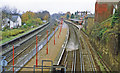
Image Map
Images are licensed for reuse under creativecommons.org/licenses/by-sa/2.0
Notes
- Clicking on the map will re-center to the selected point.
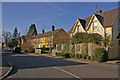
- The higher the marker number, the further away the image location is from the centre of the postcode.
Image Listing (80 Images Found)
Images are licensed for reuse under creativecommons.org/licenses/by-sa/2.0
Image
Details
Distance
1
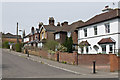
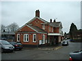
Station Approach East
Variously dated housing in a short cul de sac with subway access to Earlswood station. In the background is the spire of St John's Church, Redhill.
Image: © Ian Capper
Taken: 28 Apr 2013
0.01 miles
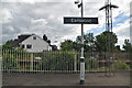
2
Station Approach East
The layout of this road and its continuation beyond the railway (the buildings in the left background are in Station Approach West) would suggest that there was once a level crossing here. Now there is only a pedestrian subway. In the background is the steeple of St Johns Church (see Image).
Image: © Ian Capper
Taken: 15 Mar 2009
0.02 miles
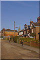
4
Earlsbrook Road
Mainly Victorian housing.
Image: © Ian Capper
Taken: 28 Apr 2013
0.03 miles
6
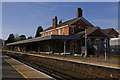
Earlswood Station
On the London to Brighton main line, the station was opened by the London Brighton and South Coast Railway in 1868, and rebuilt in 1905 after the line was quadrupled. The station building is locally listed. Only the original pair of tracks have platforms; those on the fast lines, added when the "Quarry line" was built in 1899 to bypass Redhill, are no longer in use (see Image).
Image: © Ian Capper
Taken: 15 Mar 2009
0.04 miles
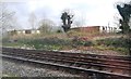
9
Earlswood station, 1992
View southward, towards Gatwick Airport, Brighton etc.: ex-LB&SCR London - Brighton main line - the first main line to be electrified (1/1/33). On the left are the Fast lines, which have come off the 'Quarry Line' from Coulsdon by-passing Redhill: the platforms on those lines were rarely used and were abandoned by 1984, all stopping trains use the platforms on the lines through Redhill.
Image: © Ben Brooksbank
Taken: 8 Nov 1992
0.05 miles
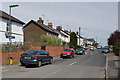
10
Princes Road
Victorian houses on the northern approach to the former Royal Earlswood Hospital.
Image: © Ian Capper
Taken: 15 Mar 2009
0.05 miles