IMAGES TAKEN NEAR TO
St. Johns Road, REDHILL, RH1 6HX
Introduction
This page details the photographs taken nearby to St. Johns Road, RH1 6HX by members of the Geograph project.
The Geograph project started in 2005 with the aim of publishing, organising and preserving representative images for every square kilometre of Great Britain, Ireland and the Isle of Man.

There are currently over 7.5m images from over14,400 individuals and you can help contribute to the project by visiting https://www.geograph.org.uk
Image Map
Images are licensed for reuse under creativecommons.org/licenses/by-sa/2.0
Notes
- Clicking on the map will re-center to the selected point.
- The higher the marker number, the further away the image location is from the centre of the postcode.
Image Listing (85 Images Found)
Images are licensed for reuse under creativecommons.org/licenses/by-sa/2.0
Image
Details
Distance
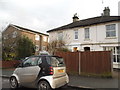
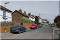
2
St John's Road at the junction of Earlsbrook Road
Image: © David Howard
Taken: 31 Jan 2016
0.02 miles
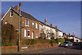
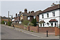
3
St John's Road
Late Victorian housing near the junction of Earlsbrook Road with St John's Road.
Image: © Ian Capper
Taken: 15 Mar 2009
0.03 miles
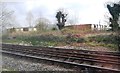
4
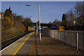
Earlswood Station
On the down platform, looking north towards St John's Road Bridge. In the distance, under the bridge, can be seen Kingsgate in Redhill. A down Thameslink train, made up of a pair of Class 319 units, is passing through on the platformless fast lines.
Image: © Ian Capper
Taken: 15 Mar 2009
0.04 miles
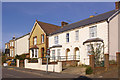
5
Earlsbrook Road
Mainly Victorian housing.
Image: © Ian Capper
Taken: 28 Apr 2013
0.05 miles
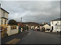
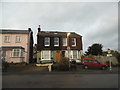
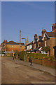
6
Earlsbrook Road
Late Victorian housing near the junction of Earlsbrook Road with St John's Road. This was one of the earliest developments in the area, with the plaque on the first house giving a date of 1884. The roads further east were developed later.
Image: © Ian Capper
Taken: 15 Mar 2009
0.05 miles
9
Station Approach East
Variously dated housing in a short cul de sac with subway access to Earlswood station. In the background is the spire of St John's Church, Redhill.
Image: © Ian Capper
Taken: 28 Apr 2013
0.07 miles
10
Station Approach East
The layout of this road and its continuation beyond the railway (the buildings in the left background are in Station Approach West) would suggest that there was once a level crossing here. Now there is only a pedestrian subway. In the background is the steeple of St Johns Church (see Image).
Image: © Ian Capper
Taken: 15 Mar 2009
0.08 miles