
IMAGES TAKEN NEAR TO
Whitepost Hill, REDHILL, RH1 6AL
Introduction
This page details the photographs taken nearby to Whitepost Hill, RH1 6AL by members of the Geograph project.
The Geograph project started in 2005 with the aim of publishing, organising and preserving representative images for every square kilometre of Great Britain, Ireland and the Isle of Man.

There are currently over 7.5m images from over14,400 individuals and you can help contribute to the project by visiting https://www.geograph.org.uk
Image Map
Images are licensed for reuse under creativecommons.org/licenses/by-sa/2.0
Notes
- Clicking on the map will re-center to the selected point.
- The higher the marker number, the further away the image location is from the centre of the postcode.
Image Listing (174 Images Found)
Images are licensed for reuse under creativecommons.org/licenses/by-sa/2.0
Image
Details
Distance
1
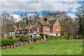
8 Whitepost Hill
House on Whitepost Hill, now named Waysmeet but marked on older maps as The Elms. Originally built in 1827 or earlier as three houses, it is now combined into one. Locally listed.
Image: © Ian Capper
Taken: 12 Apr 2021
0.01 miles
2
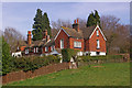
Waysmeet
An early 19th century, locally listed house on Whitepost Hill.
Image: © Ian Capper
Taken: 16 Mar 2009
0.01 miles
3
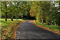
Elm Road
The route of a former farm track, linking Linkfield Street and Whitepost Hill (the latter seen in the background). On the right, behind the second wooden post, is Waterslade Spring (see Image).
Image: © Ian Capper
Taken: 9 Oct 2011
0.05 miles
4
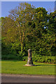
Drinking fountain, Whitepost Hill, Redhill
This drinking fountain was originally at Shaws Corner before it was displaced by the War Memorial erected there in 1923 (see Image).
For close up see Image
Image: © Ian Capper
Taken: 7 May 2008
0.05 miles
5
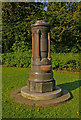
Drinking fountain, Whitepost Hill, Redhill
See Image for wider view of site.
The fountain was erected in memory of Edward F Gedge, a former Borough Councillor, by the congregation of St Matthew's Church, Redhill, where he had served as churchwarden for many years. He died in Zermatt, Switzerland, in 1897 and is buried in the churchyard of the English church there - see https://media.geograph.org.uk/files/ec5decca5ed3d6b8079e2e7e7bacc9f2/IMGP4671_.jpg.
See Image for close up of inscription.
Image: © Ian Capper
Taken: 7 May 2008
0.05 miles
6
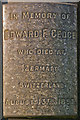
Inscription on Drinking Fountain, Whitepost Hill, Redhill
Close up of inscription on the fountain (see Image).
On the other side of the fountain is a quotation from John 4v14, linking the physical and spiritual:
"Whosoever drinketh of the water that I shall give him shall never thirst".
Image: © Ian Capper
Taken: 7 May 2008
0.05 miles
7
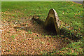
Waterslade Spring
One of a number of springs around Redhill Common - see Image for another one. Although its accompanying pool is obvious, it has been largely dry for some years. The white brick above the arch originally carried the words Waterslade Spring. The name derives from the farm that used to be here, Waterslade Farm, before it was developed in the 1870s. For a wider view, see Image
Image: © Ian Capper
Taken: 9 Oct 2011
0.05 miles
8
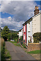
Whitepost Hill
These cottages are unusual, in that whilst their address is Whitepost Hill, they are more readily accessed off Elm Road (just visible in the background, beyond the trees), with what is more usually considered as Whitepost Hill being the road to the south (shown in yellow on the 1:50,000 map).
Image: © Ian Capper
Taken: 12 Sep 2010
0.07 miles
9
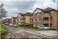
Waterslade
Late 1980s development of flats in 5 blocks in Elm Road, replacing 4 detached Edwardian houses used as nurses' accommodation.
Image: © Ian Capper
Taken: 1 Mar 2020
0.07 miles
10
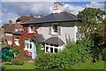
The Old Rising Sun
A former pub ("The Rising Sun"), which closed in 1910 and is now a private house. It is locally listed.
Image: © Ian Capper
Taken: 12 Sep 2010
0.07 miles