IMAGES TAKEN NEAR TO
Elm Road, REDHILL, RH1 6AJ
Introduction
This page details the photographs taken nearby to Elm Road, RH1 6AJ by members of the Geograph project.
The Geograph project started in 2005 with the aim of publishing, organising and preserving representative images for every square kilometre of Great Britain, Ireland and the Isle of Man.

There are currently over 7.5m images from over14,400 individuals and you can help contribute to the project by visiting https://www.geograph.org.uk
Image Map
Images are licensed for reuse under creativecommons.org/licenses/by-sa/2.0
Notes
- Clicking on the map will re-center to the selected point.
- The higher the marker number, the further away the image location is from the centre of the postcode.
Image Listing (177 Images Found)
Images are licensed for reuse under creativecommons.org/licenses/by-sa/2.0
Image
Details
Distance
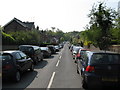
1
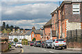
Ranelagh Road
The area now covered by Ranelagh Road and its neighbours, Shrewsbury Road and Brownlow Road, was formerly Waterslade Farm, which was bought for development in 1869 by the United Land Company. The line of the road appears, without housing, in the 1871 large scale map, with building presumably starting soon after.
Image: © Ian Capper
Taken: 9 Oct 2011
0.03 miles
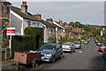
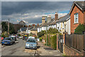
2
Redhill: Ranelagh Road
Looking south from its junction with Hatchlands Road
Image: © Dr Neil Clifton
Taken: 18 Apr 2011
0.04 miles
3
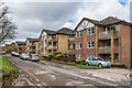
Waterslade
Late 1980s development of flats in 5 blocks in Elm Road, replacing 4 detached Edwardian houses used as nurses' accommodation.
Image: © Ian Capper
Taken: 1 Mar 2020
0.04 miles
4
Shrewsbury Road
Late Victorian housing in Shrewsbury Road.
Image: © Ian Capper
Taken: 12 Apr 2021
0.05 miles
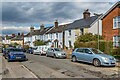
5
Shrewsbury Road
Looking along Shrewsbury Road, with part of Shrewsbury Court Independent Hospital on the right.
Image: © Ian Capper
Taken: 12 Apr 2021
0.05 miles
6
Shrewsbury Road
Late Victorian housing in Shrewsbury Road.
Image: © Ian Capper
Taken: 12 Apr 2021
0.05 miles
7
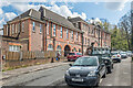
Shrewsbury Court Independent Hospital
The Shrewsbury Road frontage of Shrewsbury Court Independent Hospital, a private hospital on Whitepost Hill, providing psychiatric rehabilitation services for patients suffering from long term mental illness. The first building on the site (not seen in this photo) dates from 1871, when the Reigate Cottage Hospital moved here from Albert Road North (see Image) and was renamed the Reigate and Redhill Cottage Hospital. A wing was added in 1907 with the extension along Shrewsbury Road (seen here) being added in 1923. Over the years, the name changed a number of times, initially to the Reigate and Redhill Hospital, then the Reigate and Redhill General Hospital and from 1923 the East Surrey Hospital. From 1980, its role began to transfer to Redhill General Hospital, with total closure in 1983, with the building subsequently taking on its current role.
Image: © Ian Capper
Taken: 12 Apr 2021
0.06 miles
8
Elm Road
The route of a former farm track, linking Linkfield Street and Whitepost Hill (the latter seen in the background). On the right, behind the second wooden post, is Waterslade Spring (see Image).
Image: © Ian Capper
Taken: 9 Oct 2011
0.06 miles
9
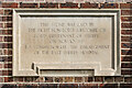
Foundation stone, Shrewsbury Court Independent Hospital
Foundation stone on the Shrewsbury Road frontage of Shrewsbury Court Independent Hospital, a private hospital on Whitepost Hill, providing psychiatric rehabilitation services for patients suffering from long term mental illness. The first building on the site dates from 1871, when the Reigate Cottage Hospital moved here from Albert Road North (see Image) and was renamed the Reigate and Redhill Cottage Hospital. A wing was added in 1907 with the extension along Shrewsbury Road (the one for which this foundation stone was laid) being added in 1923. Over the years, the name changed a number of times, initially to the Reigate and Redhill Hospital, then the Reigate and Redhill General Hospital and from 1923 the East Surrey Hospital. From 1980, its role began to transfer to Redhill General Hospital, with total closure in 1983, with the building subsequently taking on its current role.
The stone reads: "This stone was laid by the Right Hon Lord Ashcombe CB Lord Lieutenant of Surrey on Nov 10 1923 to commemorate the enlargement of the East Surrey Hospital". For a wider view of this wing, see Image, with the stone visible to the left of the entrance.
Image: © Ian Capper
Taken: 12 Apr 2021
0.06 miles
10
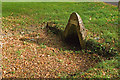
Waterslade Spring
One of a number of springs around Redhill Common - see Image for another one. Although its accompanying pool is obvious, it has been largely dry for some years. The white brick above the arch originally carried the words Waterslade Spring. The name derives from the farm that used to be here, Waterslade Farm, before it was developed in the 1870s. For a wider view, see Image
Image: © Ian Capper
Taken: 9 Oct 2011
0.06 miles