IMAGES TAKEN NEAR TO
Vita Close, HAYWARDS HEATH, RH16 4ZJ
Introduction
This page details the photographs taken nearby to Vita Close, RH16 4ZJ by members of the Geograph project.
The Geograph project started in 2005 with the aim of publishing, organising and preserving representative images for every square kilometre of Great Britain, Ireland and the Isle of Man.

There are currently over 7.5m images from over14,400 individuals and you can help contribute to the project by visiting https://www.geograph.org.uk
Image Map
Images are licensed for reuse under creativecommons.org/licenses/by-sa/2.0
Notes
- Clicking on the map will re-center to the selected point.
- The higher the marker number, the further away the image location is from the centre of the postcode.
Image Listing (19 Images Found)
Images are licensed for reuse under creativecommons.org/licenses/by-sa/2.0
Image
Details
Distance
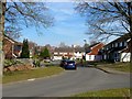
1
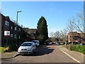
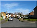
Burchetts Close, Haywards Heath
A cul de sac off Bolding Way that was constructed during the 1980s.
Image: © Simon Carey
Taken: 7 Mar 2015
0.09 miles
2
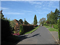
Rookery Way, Fox Hill
One of four cul-de-sacs that are located on the western side of Fox Hill, the B2112, in the suburb of the same name. The road was laid out in the late 1930s but was not developed until after the war on land that was once part of Keymer parish.
Image: © Simon Carey
Taken: 10 Apr 2011
0.11 miles
3
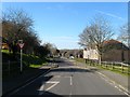
Bolding Way, Haywards Heath
Part of an estate built in the 1980s with this road providing the access between Rocky Lane and an already existing Vale Road.
Image: © Simon Carey
Taken: 7 Mar 2015
0.15 miles
4
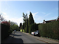
Wythwood, Fox Hill
Small cul-de-sac off Image in the suburb of Fox Hill that lies along the western side of the B2112. According to Wivelsfield's 1843 tithe map this was once two fields called Rough Common Field and Rough Piece belonging to nearby Scrase's Farm that became the site of a large house built between the wars called Wythwood which was demolished in the 1960s.
Image: © Simon Carey
Taken: 10 Apr 2011
0.16 miles
5
Sandy Vale, Haywards Heath
This section of the residential road was added in the 1980s and is located at the eastern end of the original 1960s development.
Image: © Simon Carey
Taken: 7 Mar 2015
0.17 miles
6
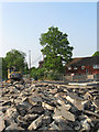
New Roundabout, Haywards Heath Relief Road (3)
The new part of the roundabout as viewed in Image has now been surfaced and is being used allowing the old part of the B2112 to be torn up in readiness for work on this side. The house to the right is Briar Lea whilst part of the new junction from Rocky Lane has been built on the site of the former Rookery Lane tollbooth.
Image: © Simon Carey
Taken: 30 Apr 2011
0.18 miles
7
Old Entrance, Colwell Road
Formerly a crossroads with Rocky Lane and Wivelsfield Road, the B2112. A Image is being constructed for the forthcoming Haywards Heath relief road which will follow the course of Rocky Lane opposite then head down a new route to the left.
This area of Haywards Heath was until 1934 part of the parish of Wivelsfield.
Image: © Simon Carey
Taken: 10 Apr 2011
0.19 miles
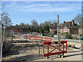
8
New Roundabout, Haywards Heath Relief Road (1)
Replacing the former junction with the B2112 and two minor routes, Rocky Lane and Colwell Road. The rerouted A272 will cross the roundabout east-west, see Image A small open area that previously existed in front of the house on the left was once the location of a toll booth for users of the former turnpike.
This area of Haywards Heath was until 1934 part of the parish of Wivelsfield.
Image: © Simon Carey
Taken: 10 Apr 2011
0.19 miles
9
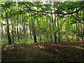
Anscombe Wood
A woodbank in the foreground marks the former boundary between the wood and some cottages that were marked on late 19th century maps but had disappeared by 1910. A fair portion of the wood has been grubbed to make way for the new Haywards Heath relief road.
Image: © Simon Carey
Taken: 30 Apr 2011
0.19 miles
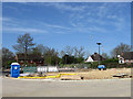
10
Sandrocks Way, Haywards Heath
A cul de sac off Sandy Vale built in the 1960s on the site of Rumbolds Wood.
Image: © Simon Carey
Taken: 7 Mar 2015
0.19 miles