IMAGES TAKEN NEAR TO
Southdowns Park, HAYWARDS HEATH, RH16 4XJ
Introduction
This page details the photographs taken nearby to Southdowns Park, RH16 4XJ by members of the Geograph project.
The Geograph project started in 2005 with the aim of publishing, organising and preserving representative images for every square kilometre of Great Britain, Ireland and the Isle of Man.

There are currently over 7.5m images from over14,400 individuals and you can help contribute to the project by visiting https://www.geograph.org.uk
Image Map (Loading...)


Getting Data...Please wait
Leaflet Map data © OpenStreetMap
Images are licensed for reuse under creativecommons.org/licenses/by-sa/2.0
Notes
- Clicking on the map will re-center to the selected point.
- The higher the marker number, the further away the image location is from the centre of the postcode.
Image Listing (66 Images Found)
Images are licensed for reuse under creativecommons.org/licenses/by-sa/2.0
Image
Details
Distance
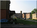
1
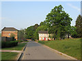
Southdowns Park
The redeveloped St Francis Hospital with part of Lockhart Court on the left and The Willows to the right, the latter was former staff housing constructed in the 1960s.
Image: © Simon Carey
Taken: 30 Apr 2011
0.02 miles
2
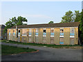
Ashurst, Southdowns Park
A former male staff hostel for St Francis Hospital built in the 1960s. It is currently awaiting redevelopment.
Image: © Simon Carey
Taken: 30 Apr 2011
0.03 miles
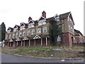
3

Southdowns Park
Originally the Sussex County Lunatic Asylum (1859) it changed its name to St Francis when coming within the NHS in 1948. It closed and the listed building has been converted into private housing.
Image: © Nigel Freeman
Taken: 5 Jul 2005
0.04 miles
5
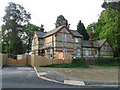
Lodge, Colwell Road
Built in 1860 at the service gate to what was originally the Sussex County Lunatic Asylum and later St Francis Hospital until its closure in 1995. Now a private home.
This area was originally part of Wivelsfield parish until transferred to Haywards Heath in 1934.
Image: © Simon Carey
Taken: 30 Apr 2011
0.04 miles
6
Southdowns Park
A view of buildings that have been converted and those awaiting conversion. To the immediate left is Image, to the right is Image whilst beyond are parts of Lockhart Court, Park West and Arundel Mews which once formed part of the female section of the former hospital.
Image: © Simon Carey
Taken: 30 Apr 2011
0.05 miles
7
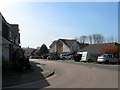
St Francis Close, Haywards Heath
Built in the 1990s on the site of two semi-detached houses called Acunba and Hazeldene and in the process eradicating the northern end of St John's Road.
Image: © Simon Carey
Taken: 7 Apr 2015
0.05 miles
8
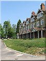
Linden House
Former nurses residences built during the Edwardian era and currently awaiting redevelopment.
Image: © Simon Carey
Taken: 30 Apr 2011
0.06 miles
9
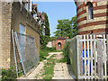
Former Staff Launderette
Image: © Simon Carey
Taken: 30 Apr 2011
0.06 miles
10
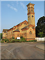
Former Hospital Chapel
Located next to the main entrance and constructed at the same time as the Asylum it served. The chapel closed with the hospital in 1995 and was vacant for a few years but is now a nursery. Like the former hospital it is built in an Italianate style.
Image: © Simon Carey
Taken: 30 Apr 2011
0.06 miles