IMAGES TAKEN NEAR TO
Kleinwort Close, HAYWARDS HEATH, RH16 4XG
Introduction
This page details the photographs taken nearby to Kleinwort Close, RH16 4XG by members of the Geograph project.
The Geograph project started in 2005 with the aim of publishing, organising and preserving representative images for every square kilometre of Great Britain, Ireland and the Isle of Man.

There are currently over 7.5m images from over14,400 individuals and you can help contribute to the project by visiting https://www.geograph.org.uk
Image Map
Images are licensed for reuse under creativecommons.org/licenses/by-sa/2.0
Notes
- Clicking on the map will re-center to the selected point.
- The higher the marker number, the further away the image location is from the centre of the postcode.
Image Listing (65 Images Found)
Images are licensed for reuse under creativecommons.org/licenses/by-sa/2.0
Image
Details
Distance
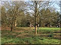
1
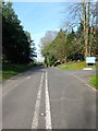
Isaac's Lane, Haywards Heath
The old course of the A273 which was rerouted in the first phase of the construction of the Haywards Heath relief road around 2001. The road ends just south of the junction with Bolnore Farm Lane. To the left is Image whilst to the right is the entrance to Image
Image: © Simon Carey
Taken: 12 Apr 2015
0.04 miles
2
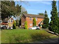
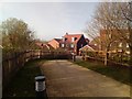
Downlands Cottage, Isaac's Lane, Haywards Heath
Built in the first decade of the 20th century when part of Parkfield School, see Image To the left is part of the Old Coach House which dates from the 1880s.
Image: © Simon Carey
Taken: 12 Apr 2015
0.04 miles
3
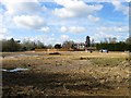
New Development, Haywards Heath
Once a field called New Park according to Cuckfield's 1843 tithe map it later became playing fields for first Parkfield School then after 1974 Downlands Park special school and when that closed the field was left to waste and is now being developed. The building beyond is Downlands Park, the former school buildings, which is now a BUPA nursing home.
Image: © Simon Carey
Taken: 30 Mar 2015
0.05 miles
4
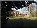
Downlands Park, Isaac's Lane, Haywards Heath
Currently a nursing home run by BUPA. The house dates from around the 1880s and was built on a former field called The New Park and originally called Parkfield. In the early 1900s the house became a private boys prep school which amalgamated in the 1930s with another from Brighton called The Wick to become Wick and Parkfield School. The school operated for nearly 70 years closing in 1974 whereupon it was acquired by Downlands College, then based in Saltdean near Brighton, a specialist school for those with severe dyslexia and dysgraphia. Downlands continued until it closed in 1985 as result of changes in local authority funding for special schools. Viewed from a side entrance on Bolnore Farm Lane.
Image: © Simon Carey
Taken: 12 Apr 2015
0.05 miles
5
Butlers Green
An old piece of common land, triangular in shape, and bounded by Butlers Green Road, Isaac's Lane and a former farm now called The Paddocks. The depression in the ground marks the site of a former pond which seems to have been drained and planted by the early 20th century.
Image: © Simon Carey
Taken: 12 Apr 2015
0.06 miles
6
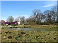
Pond, New Development, Haywards Heath
A new pond at the south western edge of a development called Lucastes. Butlers Green Road is beyond the hedgerow.
Image: © Simon Carey
Taken: 12 Apr 2015
0.08 miles
7
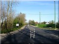
Butlers Green Road, Haywards Heath
Until last autumn this was the A272 but has now been redesigned the B2272 after the opening of the Haywards Heath relief road. To the immediate right is the junction with the old route of Isaac's Lane, former the A273, whilst developments are in the process of being built either side of the road. Beyond the hedge to the left will be Lucastes, see Image, whilst beyond the green fence to the right is Image The cottages just in view beyond are Image
Image: © Simon Carey
Taken: 12 Apr 2015
0.08 miles
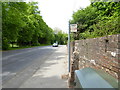
9
Footpath connecting Butlers Green Road and Knights Close
Image: © Thoma
Taken: 3 Apr 2017
0.08 miles
10
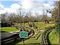
Miniature Railway, Beech Hurst Gardens, Haywards Heath
This loop around what is now known as Wildflower Meadow was added as an extension to the original circuit in 1974 and includes a fifty yard tunnel at the western end. In the foreground is Club House Curve to the left and Parkfield Curve to the right. The field is northern portion of Whitegate Field according to Cuckfield's 1843 tithe map, see Image for what is now the southern part.
Image: © Simon Carey
Taken: 30 Mar 2015
0.09 miles