IMAGES TAKEN NEAR TO
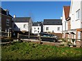
Wheat Croft, HAYWARDS HEATH, RH16 4UU
Introduction
This page details the photographs taken nearby to Wheat Croft, RH16 4UU by members of the Geograph project.
The Geograph project started in 2005 with the aim of publishing, organising and preserving representative images for every square kilometre of Great Britain, Ireland and the Isle of Man.

There are currently over 7.5m images from over14,400 individuals and you can help contribute to the project by visiting https://www.geograph.org.uk
Image Map
Images are licensed for reuse under creativecommons.org/licenses/by-sa/2.0
Notes
- Clicking on the map will re-center to the selected point.
- The higher the marker number, the further away the image location is from the centre of the postcode.
Image Listing (62 Images Found)
Images are licensed for reuse under creativecommons.org/licenses/by-sa/2.0
Image
Details
Distance
1
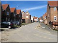
Chandlers Field Drive, Bolnore Village
Recently completed part of the Bolnore development which has yet to appear on any OS map so the map references are a rough guess. According to Cuckfield's 1843 tithe map this road occupies a former field called Lower Eight Acres.
Image: © Simon Carey
Taken: 7 Mar 2015
0.04 miles
2
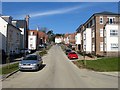
Trubwick Avenue, Bolnore Village
Part of a recently completed part of the Bolnore development linking Parkfield Way to Renfields.
Image: © Simon Carey
Taken: 7 Mar 2015
0.09 miles
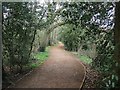
3
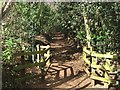
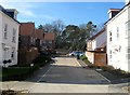
Bridleway, Bolnore Village
The section of the surfaced bridleway links Trubwick Avenue to Bolnore Farm Lane, the northern end of the route which heads south then swings east to Ashenground Bridge travelling through the new Bolnore village development. The route is ancient and is clearly marked on a 1638 estate map where it is called Half Street Lane.
Image: © Simon Carey
Taken: 31 Mar 2015
0.10 miles
4
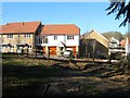
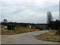
New Development, Bolnore Village
Located to the immediate north of Image Bolnore village is a completely new development in the south western corner of Haywards Heath that includes the construction of 851 homes in what is a new community. The development began around 2001 and included the new relief road for the town.
Image: © Simon Carey
Taken: 17 Feb 2015
0.11 miles
5
Renfields, Bolnore Village
Part of the new development began in 2001 that will eventually include 851 new homes on the south western corner of Haywards Heath.
Image: © Simon Carey
Taken: 17 Feb 2015
0.12 miles
6
Saddlers Way, Bolnore Village
The new road will be the access route for the last phase of the Bolnore village development. This section occupies a former field called Crabtree Field, according to Cuckfield's 1843 tithe map.
Image: © Simon Carey
Taken: 30 Mar 2015
0.12 miles
7
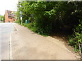
Footpath junction in Bolnore Village
The road is shown on OS mapping as Trubwick Avenue.
Image: © Shazz
Taken: 20 May 2016
0.12 miles
8
Bridleway, Bolnore Village
The bridleway is surfaced between Bolnore Farm Road and Ashenground Bridge and runs through the new bolnore village development. The route is ancient and is marked on a 1638 estate map where it is called Half Street Lane. The wooded area to the left is now part of a nature reserve run by the Friends of Ashenground and Bolnore Woods who have named it King Street Copse. This section runs between it crossing Renfields and Trubwick Avenue.
Image: © Simon Carey
Taken: 31 Mar 2015
0.12 miles
9
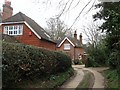
St Catherine's Cottage, Bolnore Farm Lane, Haywards Heath
Built in the first decade of the 20th century at a former entrance of the Convent of the Holy Cross. The track from Isaac's Lane ends at this point though the bridleway continues southwards to the right.
Image: © Simon Carey
Taken: 30 Mar 2015
0.12 miles
10
Rushy Grove, Bolnore Village
A cul de sac off Image that has been recently completed and occupied. Amongst the trees beyond is the old bridleway that runs from Ashenground Bridge to Isaac's Lane.
Image: © Simon Carey
Taken: 7 Mar 2015
0.13 miles