IMAGES TAKEN NEAR TO
Sheppeys, HAYWARDS HEATH, RH16 4NU
Introduction
This page details the photographs taken nearby to Sheppeys, RH16 4NU by members of the Geograph project.
The Geograph project started in 2005 with the aim of publishing, organising and preserving representative images for every square kilometre of Great Britain, Ireland and the Isle of Man.

There are currently over 7.5m images from over14,400 individuals and you can help contribute to the project by visiting https://www.geograph.org.uk
Image Map
Images are licensed for reuse under creativecommons.org/licenses/by-sa/2.0
Notes
- Clicking on the map will re-center to the selected point.
- The higher the marker number, the further away the image location is from the centre of the postcode.
Image Listing (22 Images Found)
Images are licensed for reuse under creativecommons.org/licenses/by-sa/2.0
Image
Details
Distance
1
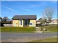
The Ascension Church, Vale Road, Haywards Heath
The current building dates from 2008 and replaced an older octagonal shaped structure that was built in the 1960s when much of the estate here was completed.
Image: © Simon Carey
Taken: 7 Mar 2015
0.06 miles
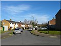
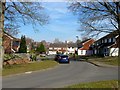
2
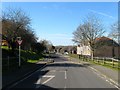
Bolding Way, Haywards Heath
Part of an estate built in the 1980s with this road providing the access between Rocky Lane and an already existing Vale Road.
Image: © Simon Carey
Taken: 7 Mar 2015
0.08 miles
4
Southdown Close, Haywards Heath
Built in the early 1960s on the site of Ashenground Wood along with much of the estate that lies to the immediate east of the railway. Viewed from the junction with Vale Road.
Image: © Simon Carey
Taken: 7 Mar 2015
0.10 miles
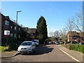
5
Sandrocks Way, Haywards Heath
A cul de sac off Sandy Vale built in the 1960s on the site of Rumbolds Wood.
Image: © Simon Carey
Taken: 7 Mar 2015
0.12 miles
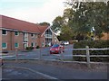
6
Burchetts Close, Haywards Heath
A cul de sac off Bolding Way that was constructed during the 1980s.
Image: © Simon Carey
Taken: 7 Mar 2015
0.15 miles
7
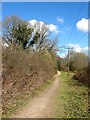
Permissive Footpath, Pierce's Wood
The footpath runs from the lower village of the Bolnore development to Ashenground Bridge skirting the eastern side of a local nature reserve, the remnant of woodlands left after the rest were removed for the construction of the new estate, and the railway line.
Image: © Simon Carey
Taken: 31 Mar 2015
0.15 miles
8
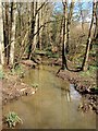
Unnamed Stream, Ashenground Park
A minor tributary of the eastern branch of the River Adur which rises within the local nature reserve and joins the river to the south of Fox Hill.
Image: © Simon Carey
Taken: 31 Mar 2015
0.16 miles
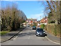
9
Sandy Vale, Haywards Heath
This section of the residential road was added in the 1980s and is located at the eastern end of the original 1960s development.
Image: © Simon Carey
Taken: 7 Mar 2015
0.16 miles
10
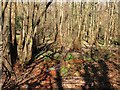
Ashenground Park
Once part of Ashenground Wood but this small section was separated by the construction of the railway in 1841 and deemed to be part of neighbouring Catt's Wood until the late 1960s when OS maps began marking this section of woodland as Ashenground Park. The Friends of Ashenground and Bolnore Woods have now renamed the remnant of woodland as Ashenground Wood. The orange on the boggy ground denotes the existence of iron ore deposits.
Image: © Simon Carey
Taken: 31 Mar 2015
0.17 miles