IMAGES TAKEN NEAR TO
Haywards Road, HAYWARDS HEATH, RH16 4JB
Introduction
This page details the photographs taken nearby to Haywards Road, RH16 4JB by members of the Geograph project.
The Geograph project started in 2005 with the aim of publishing, organising and preserving representative images for every square kilometre of Great Britain, Ireland and the Isle of Man.

There are currently over 7.5m images from over14,400 individuals and you can help contribute to the project by visiting https://www.geograph.org.uk
Image Map
Images are licensed for reuse under creativecommons.org/licenses/by-sa/2.0
Notes
- Clicking on the map will re-center to the selected point.
- The higher the marker number, the further away the image location is from the centre of the postcode.
Image Listing (60 Images Found)
Images are licensed for reuse under creativecommons.org/licenses/by-sa/2.0
Image
Details
Distance
1
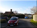
Courtlands, Haywards Heath
A small cul de sac located on the western side of Image built in the 1960s on the former grounds of Little Haywards Farm. The farmhouse still stands on the left and dates back to the early 15th century when it would have faced out onto the open common of Haywards Heath.
Image: © Simon Carey
Taken: 8 Feb 2015
0.05 miles
2
Ryecroft, Haywards Heath
A cul de sac off Wood Ride built in the 1980s on former allotments.
Image: © Simon Carey
Taken: 8 Feb 2015
0.10 miles
3
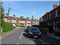
Gower Road
Residential street linking Ashenground Road to Haywards Road developed during the first decade of the 20th century.
Image: © Simon Carey
Taken: 10 Apr 2011
0.10 miles
4
Ashenground Road
The road existed before the houses heading west towards Ashenground Wood which was built in the 1960s. The road itself was developed intermittently, the first houses on the left appearing in the first decade of the 20th century.
Image: © Simon Carey
Taken: 10 Apr 2011
0.10 miles
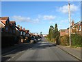
5
Park Road, Haywards Heath
A residential road running from Wood Ride in the west to Haywards Road in the east and developed in the 1930s to the south of Victoria Park on the site of the former Great Haywards Wood.
Image: © Simon Carey
Taken: 8 Feb 2015
0.11 miles
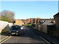
6
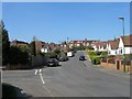
Vale Road, Haywards Heath
The road currently heads south from Ashenground Road then turns westwards at the junction in view to continue down to Bolding Way. Originally marked as Edward Road on a 1937 OS map and planned to join Wivelsfield Road further to the south, by the 1950s it had become Vale Road with Edward Road beginning at the junction.
Image: © Simon Carey
Taken: 7 Apr 2015
0.13 miles
7
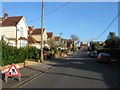
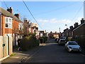
Haywards Road, Haywards Heath
Linking Ashenground Road to the south with South Road to the north. The modern road roughly follows the course of a much older one, marked on a 1638 estate map, which ran across the old heath to provide access for Little Haywards Farm, see Image Straightened by the enclosure of the heath in 1858 and initially known as little Haywards Road it was gradually developed through the rest of the 19th century.
Image: © Simon Carey
Taken: 8 Feb 2015
0.13 miles
8
Wood Ride, Haywards Heath
A residential road linking Ashenground Road to the south and Park Road to the north. Built in the 1930s on the site of what was Great Haywards Wood.
Image: © Simon Carey
Taken: 8 Feb 2015
0.13 miles
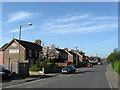
9
Gower Road, Haywards Heath
Developed as lower class housing in the 1880s and running from Ashenground Road in the south to Haywards Road to the north with a spur eastwards to Sussex road, see Image
Image: © Simon Carey
Taken: 8 Feb 2015
0.14 miles
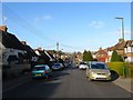
10
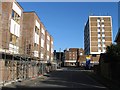
Gower Road, Haywards Heath
The road runs from Ashenground Road in the south to Haywards Road to the north with a third part heading east to Sussex Road. This is part of the latter with a new development on the left and Stockwell Court, the block of flats, to the right which was built in the early 1970s.
Image: © Simon Carey
Taken: 8 Feb 2015
0.17 miles