IMAGES TAKEN NEAR TO
Middle Village, HAYWARDS HEATH, RH16 4GJ
Introduction
This page details the photographs taken nearby to Middle Village, RH16 4GJ by members of the Geograph project.
The Geograph project started in 2005 with the aim of publishing, organising and preserving representative images for every square kilometre of Great Britain, Ireland and the Isle of Man.

There are currently over 7.5m images from over14,400 individuals and you can help contribute to the project by visiting https://www.geograph.org.uk
Image Map (Loading...)


Getting Data...Please wait
Leaflet Map data © OpenStreetMap
Images are licensed for reuse under creativecommons.org/licenses/by-sa/2.0
Notes
- Clicking on the map will re-center to the selected point.
- The higher the marker number, the further away the image location is from the centre of the postcode.
Image Listing (60 Images Found)
Images are licensed for reuse under creativecommons.org/licenses/by-sa/2.0
Image
Details
Distance
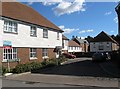
1
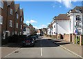
Updown Hill, Bolnore Village
Updown Hill actually forms a square around the central commercial area of the development which contains a small Co-op supermarket and a hairdressers. This is the southern part with Woodcote House on the right.
Image: © Simon Carey
Taken: 31 Mar 2015
0.03 miles
2
Cattswood Lane, Bolnore Village
A narrow lane which has vehicle access in parts which runs around the western side of the development and takes its name from the former wood that was felled to build this section of the Bolnore development.
Image: © Simon Carey
Taken: 7 Mar 2015
0.03 miles
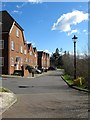
3
Woodbanke Lane, Bolnore Village
Along with fake barns and stables we also have fake narrow winding lanes with ye olde English spelling. This one runs south from Updown Hill to Cattswood Lane.
Image: © Simon Carey
Taken: 7 Mar 2015
0.04 miles
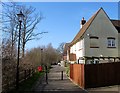
4
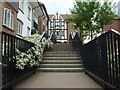
Steps to the south entrance to Bolnore Village Square
Heading north from Middle Village, this path heads toward the village square.
Image: © Curtis Bateman
Taken: 26 Jul 2010
0.05 miles
5
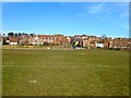
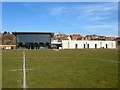
Tim Farmer Recreation Ground, Bolnore Village
The eastern end of the large recreation ground in the middle of the Bolnore development. See also Image
Image: © Simon Carey
Taken: 7 Mar 2015
0.06 miles
6
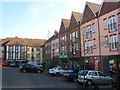
Co-operative Store, Middle Village, Bolnore Village
The main village square in the development contains the Co-op and a ladies hairdressers which is out of shot to the right. The square kind of has a continental feel to it but much is given over to car parking. There does not seem to be room for any extra shops either, at the very least a cafe which outside tables would be a nice touch. A lost opportunity here to turn this into a central area for the community.
Image: © Simon Carey
Taken: 7 Mar 2015
0.06 miles
7
Updown Hill, Bolnore Village
Updown Hill forms a square around Image in the middle part of the Bolnore development with this section on the western side containing some fake timber framing.
Image: © Simon Carey
Taken: 7 Mar 2015
0.06 miles
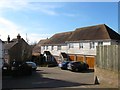
8
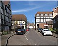
Woodside, Bolnore Village
Bolnore village will eventually contain over 800 homes housing over 2000 residents yet little provision has been made for services to this community, there is no church or pub, and only one shop. As a consequence the residents have battled and succeeded in getting this building constructed which will act as a community centre and at present contains the only licensed premises in the village.
Image: © Simon Carey
Taken: 7 Mar 2015
0.07 miles
9
Farriers Lea, Bolnore Village
A cul de sac off Middle Village at the southern end of the middle portion of the new development.
Image: © Simon Carey
Taken: 31 Mar 2015
0.08 miles
10
Weavers Mead, Bolnore Village
A cul de sac that heads south from Updown Hill in the shape of a 'T'.
Image: © Simon Carey
Taken: 31 Mar 2015
0.08 miles