IMAGES TAKEN NEAR TO
Western Road, HAYWARDS HEATH, RH16 3LN
Introduction
This page details the photographs taken nearby to Western Road, RH16 3LN by members of the Geograph project.
The Geograph project started in 2005 with the aim of publishing, organising and preserving representative images for every square kilometre of Great Britain, Ireland and the Isle of Man.

There are currently over 7.5m images from over14,400 individuals and you can help contribute to the project by visiting https://www.geograph.org.uk
Image Map
Images are licensed for reuse under creativecommons.org/licenses/by-sa/2.0
Notes
- Clicking on the map will re-center to the selected point.
- The higher the marker number, the further away the image location is from the centre of the postcode.
Image Listing (62 Images Found)
Images are licensed for reuse under creativecommons.org/licenses/by-sa/2.0
Image
Details
Distance
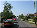
1
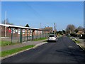
North Road
A continuation of Eastern Road as it turns west towards a junction with Western Road. The road was laid out on the site of Petlands Wood before the First World War though it was rerouted after and the houses on the left built in the 1920s. Those on the right, including a number of bungalows out of shot were not added until the 1960s.
Image: © Simon Carey
Taken: 30 Apr 2011
0.05 miles
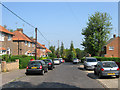
2
North Road, Haywards Heath
A residential road that runs between Western Road and Eastern Road with the southern side to the left developed in the 1920s on the site of Petlands Wood and the northern side not completed until the 1960s.
Image: © Simon Carey
Taken: 7 Apr 2015
0.06 miles
3
Eastern Road
Laid out before the First World War with the southern part up the hill in the distance developed during the 1920s. This part developed at a much slower pace having originally been the location of brickfields with a primary school added in the 1940s, the Eastern Road Gospel Hall on the right and neighbouring scout headquarters in the 1960s, whilst the houses on the left was still waste until the end of the 1970s when Albert Close was constructed.
Image: © Simon Carey
Taken: 30 Apr 2011
0.06 miles
4
Franklynn Gospel Hall, Eastern Road, Haywards Heath
Built sometime in the 1960s for the Open Brethren and located to the immediate north of Image
Image: © Simon Carey
Taken: 7 Apr 2015
0.07 miles
5
Army Cadets Training Centre, Eastern Road, Haywards Heath
Built in the mid 1960s to replace the old drill hall that was located at the cattle market. Beyond is Image
Image: © Simon Carey
Taken: 7 Apr 2015
0.08 miles
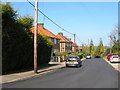
6
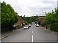
Western Road
Linking New England Road with Franklynn Road (A272). Laid out through Petlands Wood in the 1920s and gradually built up over the next 30 years. The dip in the road marks the entry to the towns cemetery.
Image: © Simon Carey
Taken: 30 Aug 2007
0.08 miles
7
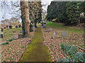
Haywards Heath Cemetery - top path, south side
The cemetery is along the south slope of a stream valley.
Image: © Robin Webster
Taken: 19 Feb 2023
0.09 miles
9
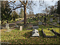
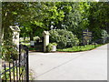
In Haywards Heath Cemetery
Section AC in the foreground, according to a plan at the entrance. The section identification letters are presumably to some logical system, but it is far from obvious what it is.
Image: © Robin Webster
Taken: 19 Feb 2023
0.10 miles
10
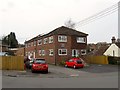
Auckland Place, Western Road, Haywards Heath
Originally a builders yard that was converted into an office block called Progress House in the 1970s. The block was empty when I last passed this way, see Image, and during 2014 was converted into flats.
Image: © Simon Carey
Taken: 30 Mar 2015
0.10 miles