IMAGES TAKEN NEAR TO
Marylands, New England Road, HAYWARDS HEATH, RH16 3JZ
Introduction
This page details the photographs taken nearby to Marylands, New England Road, RH16 3JZ by members of the Geograph project.
The Geograph project started in 2005 with the aim of publishing, organising and preserving representative images for every square kilometre of Great Britain, Ireland and the Isle of Man.

There are currently over 7.5m images from over14,400 individuals and you can help contribute to the project by visiting https://www.geograph.org.uk
Image Map
Images are licensed for reuse under creativecommons.org/licenses/by-sa/2.0
Notes
- Clicking on the map will re-center to the selected point.
- The higher the marker number, the further away the image location is from the centre of the postcode.
Image Listing (57 Images Found)
Images are licensed for reuse under creativecommons.org/licenses/by-sa/2.0
Image
Details
Distance
1
Church of the Presentation, Marylands, Haywards Heath
The second and smaller of the two parish churches of St Wilfrid's. An iron building was originally erected here in 1882 and replaced by the current one in 1897. The building on the left is a small church hall whilst the cul-de-sac built in the 1980s was built in the grounds of the vicarage.
Image: © Simon Carey
Taken: 15 Aug 2015
0.03 miles
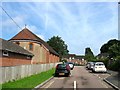
2
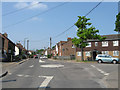
Bentswood Road, Haywards Heath
The road runs in a circular fashion from New England Road and back again further east to the point where it changes to America Lane. This section looks down towards the junction with Little Bentswood and Bentswood Crescent. The Bentswood estate was begun by the local council in the mid 1920s and largely completed by the mid 1930s with a couple editions after the war. Named after the wood it was built on.
Image: © Simon Carey
Taken: 7 Apr 2015
0.04 miles
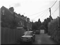
3
Bentswood Road
Erected in the 1930s as a working class estate the name deriving from the Bent family who owned land in the area during the 19th century. Bentswood Road runs from the left then up the hill, the road leading out to the right is Little Bentswood.
Image: © Simon Carey
Taken: 30 Aug 2007
0.05 miles
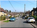
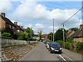
4
New England Road, Haywards Heath
Looking eastwards along the road that was laid out around the 1880s along with many of the houses visible on the left. The road becomes America Lane at the eastern junction with Bentswood Road a point which once marked the parish boundary between Cuckfield and Lindfield. The white van is pulling out of Western Road.
Image: © Simon Carey
Taken: 7 Apr 2015
0.06 miles
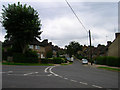
5
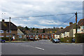
Mini Roundabout, New England Road
This side of the roundabout is America Lane, heading straight ahead is New England, whilst Bentswood Road goes off to the right. The junction marks the former parish boundary between Cuckfield and Lindfield with New England Road developed from the latter years of the Victorian era and reaching this point by 1910. Bentswood Road was developed as a large council estate during the 1930s whilst America Lane was home to an early 19th century Quaker self help settlement known initially as The Colony and later as America which survived until 1944 when all the cottages were demolished.
Image: © Simon Carey
Taken: 30 Apr 2011
0.06 miles
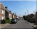
6
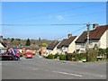
Little Bentswood, Haywards Heath
This is the name of the road straight ahead. Bentswood Road sweeps round from near right to left.
Image: © Robin Webster
Taken: 14 Mar 2010
0.07 miles
7
Little Bentswood (2), Haywards Heath
The eastern part of the road was built in the 1930s as part of the Bentswood Estate, with the northern part, see Image added after the Second World War. Viewed from the junction with Bentswood Road and Bentswood Crescent.
Image: © Simon Carey
Taken: 7 Apr 2015
0.08 miles
8
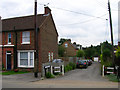
Langridge Lane
Small private lane off New England Road the houses being developed during the interwar period.
Image: © Simon Carey
Taken: 30 Aug 2007
0.09 miles
9
Langridge Lane, Haywards Heath
Small cul de sac off Western Road developed in the late 19th century initially as an access road to a house called Langridge which still stands to south amongst the trees. On the left are two sets of semi-detached cottages built in the first decade of the 20th century with Canadian Cottages on the immediate left and Quebec Cottages beyond. Between the wars, Adastra and Byways, another semi-detached pair were added beyond the hedge to the right. The garage straight ahead belongs to St Giles which was added in the 1960s, the last residence to built here.
Image: © Simon Carey
Taken: 15 Aug 2015
0.09 miles
10
Bentswood Crescent, Haywards Heath
Built in the 1930s on the site of Bent's Wood and running from Bentswood Road to Barn Cottage Lane.
Image: © Simon Carey
Taken: 15 Aug 2015
0.11 miles