IMAGES TAKEN NEAR TO
Heath Road, HAYWARDS HEATH, RH16 3AX
Introduction
This page details the photographs taken nearby to Heath Road, RH16 3AX by members of the Geograph project.
The Geograph project started in 2005 with the aim of publishing, organising and preserving representative images for every square kilometre of Great Britain, Ireland and the Isle of Man.

There are currently over 7.5m images from over14,400 individuals and you can help contribute to the project by visiting https://www.geograph.org.uk
Image Map
Images are licensed for reuse under creativecommons.org/licenses/by-sa/2.0
Notes
- Clicking on the map will re-center to the selected point.
- The higher the marker number, the further away the image location is from the centre of the postcode.
Image Listing (128 Images Found)
Images are licensed for reuse under creativecommons.org/licenses/by-sa/2.0
Image
Details
Distance
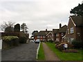
1
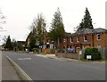
9-13, Heath Road, Haywards Heath
Heath Road is one of the earliest new roads of the town having been laid out after the enclosure of the old heath in 1858. There are no houses on the road on the 1874 OS map, however, number 13 on the right makes its first appearance on the 1897 edition whilst the two houses beyond, partially obscured by trees, were in place by the 1910 version.
Image: © Simon Carey
Taken: 30 Mar 2015
0.02 miles
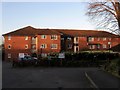
3
Trevelyan Place, Haywards Heath
Built at the turn of this century on what was formerly open ground and located off Heath Road. The footpath to the left heads south to Church Road.
Image: © Simon Carey
Taken: 30 Mar 2015
0.05 miles
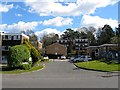
4
Jireh Court, Perrymount Road, Haywards Heath
Built sometime in the early 1960s on the site of Jireh House which had links to the Jireh Chapel a little to the north.
Image: © Simon Carey
Taken: 1 Feb 2015
0.09 miles
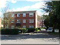
5
Clover Court, Church Road, Haywards Heath
A block of retirement flats built in 1988 on the site of a former Victorian townhouse.
Image: © Simon Carey
Taken: 8 Feb 2015
0.10 miles
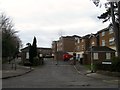
6
Highland Court, Haywards Heath
Small, private cul de sac off Church Road built in the 1960s.
Image: © Simon Carey
Taken: 1 Feb 2015
0.11 miles
7
Newton Court, Haywards Heath
Built in the 1970s on the site of two late Victorian houses and their grounds called Isenhurst and Newtons.
Image: © Simon Carey
Taken: 31 Mar 2015
0.12 miles
8
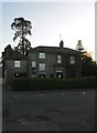
4, Church Road, Haywards Heath
A former Victorian town house now boarded up and probably awaiting redevelopment into flats. Many of these older houses were built with large grounds attached with the latter becoming far more valuable than the property standing within it.
Image: © Simon Carey
Taken: 8 Feb 2015
0.14 miles
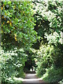
9
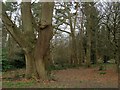
The Heath Recreation Ground, Haywards Heath
The small remnant of the former heath that existed here prior to the arrival of the railway in 1841. This wooded area lies to the south of the cricket field.
Image: © Simon Carey
Taken: 30 Mar 2015
0.14 miles
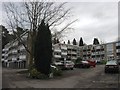
10
Arlington Court, Perrymount Road, Haywards Heath
Built in the 1980s on the site of numbers 24-26 Perrymount Road. Just visible beyond are the flats of Bodiam Court. Perrymount Road originally contained a number of houses with extensive grounds many of which have been lost to either office development or the construction of flats.
Image: © Simon Carey
Taken: 31 Mar 2015
0.15 miles