IMAGES TAKEN NEAR TO
West View, HAYWARDS HEATH, RH16 2LL
Introduction
This page details the photographs taken nearby to West View, RH16 2LL by members of the Geograph project.
The Geograph project started in 2005 with the aim of publishing, organising and preserving representative images for every square kilometre of Great Britain, Ireland and the Isle of Man.

There are currently over 7.5m images from over14,400 individuals and you can help contribute to the project by visiting https://www.geograph.org.uk
Image Map
Images are licensed for reuse under creativecommons.org/licenses/by-sa/2.0
Notes
- Clicking on the map will re-center to the selected point.
- The higher the marker number, the further away the image location is from the centre of the postcode.
Image Listing (69 Images Found)
Images are licensed for reuse under creativecommons.org/licenses/by-sa/2.0
Image
Details
Distance
1
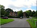
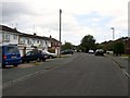
West View, Lindfield
The name of the cul de sac off Lewes Road that runs along the south eastern side of Lindfield Common. Bucklersbury is the house on the left and dates from the 1960s and partially obscured by the tree on the right is West View House which appears to have been built between the wars.
Image: © Simon Carey
Taken: 15 Aug 2015
0.01 miles
2
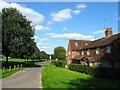
Rosmond Cottage, West View, Lindfield
A single dwelling located at the southern end of the common and built as a pair in the late 19th century.
Image: © Simon Carey
Taken: 6 Sep 2015
0.01 miles
3
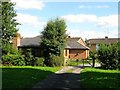
Rowstile Cottage, West View, Lindfield
One of pair built in 2001 on the site of a former scrap yard at the eastern end of the common.
Image: © Simon Carey
Taken: 6 Sep 2015
0.04 miles
4
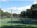
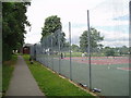
Tennis Courts, Lindfield Common
Located in the south eastern corner since the interwar era though part of its original area has been reduced to accommodate a car park on the eastern side.
Image: © Simon Carey
Taken: 6 Sep 2015
0.05 miles
5
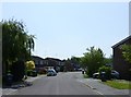
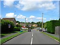
Meadow Drive, Lindfield
A cul de sac off Gravelye Lane with this section developed in the late 1960s on a former meadow adjacent to Scrase Stream.
Image: © Simon Carey
Taken: 4 Aug 2015
0.05 miles
7
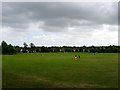
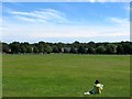
Lindfield Common
Lindfield's large common originally at the southern end of the village still survives as a public open space. A quick shower has scattered all those using it who are now returning from shelter to continue their activities.
Image: © Simon Carey
Taken: 4 Aug 2015
0.07 miles
8
Lindfield Tennis Club
A club with its own pavilion next to the cricket club.
Image: © Nigel Freeman
Taken: 6 Jul 2005
0.07 miles
9
Lindfield Common
Fairly empty on a hot summers day though there was a group of senior citizens having a picnic in the shade of a tree out of shot to the left. The houses at the far end of the common are Image with Lewes Road to the left.
Image: © Simon Carey
Taken: 9 Aug 2015
0.07 miles
10
Meadow Drive, Lindfield
The road heads west from Gravelye Lane then turns south having crossed Scrase Stream, see Image Developed in the early 1970s on the site of a former laundry, see Image, for more details. The turning on the right is Image
Image: © Simon Carey
Taken: 15 Aug 2015
0.08 miles