IMAGES TAKEN NEAR TO
Francis Road, HAYWARDS HEATH, RH16 2JB
Introduction
This page details the photographs taken nearby to Francis Road, RH16 2JB by members of the Geograph project.
The Geograph project started in 2005 with the aim of publishing, organising and preserving representative images for every square kilometre of Great Britain, Ireland and the Isle of Man.

There are currently over 7.5m images from over14,400 individuals and you can help contribute to the project by visiting https://www.geograph.org.uk
Image Map
Images are licensed for reuse under creativecommons.org/licenses/by-sa/2.0
Notes
- Clicking on the map will re-center to the selected point.
- The higher the marker number, the further away the image location is from the centre of the postcode.
Image Listing (195 Images Found)
Images are licensed for reuse under creativecommons.org/licenses/by-sa/2.0
Image
Details
Distance
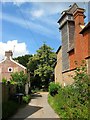
1
Francis Road, Lindfield
A cul de sac off High Street that runs to the east of the church with these terraces developed in the late 19th century. There is access to Image to the south but only by foot.
Image: © Simon Carey
Taken: 4 Aug 2015
0.01 miles
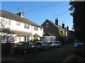
2
Francis Road, Lindfield
A cul de sac that heads south from High Street skirting the church on the eastern side before briefly turning east at this point. On the left are Church View Cottages built in the late 19th century whilst on the right the strange structure is The Pavilion, now a residence but originally built as a studio around 1890 for Charles Eamer Kempe the famous stained glass window artist who resided at Old Place in whose grounds it is located.
Image: © Simon Carey
Taken: 15 Aug 2015
0.02 miles
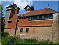
3
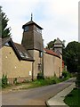
The Pavilion, Francis Road, Lindfield
Erected in 1890 by Charles Eamer Kempe as a purpose built studio for producing his stained glass windows whilst he resided in Image in whose grounds the structure is located. Since the 20th century it has been converted into a residence.
Image: © Simon Carey
Taken: 30 Aug 2015
0.02 miles
4
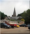
Lindfield - All Saints Church
view from the car park
Church website: http://www.allsaintslindfield.org/
Image: © Paul Gillett
Taken: 10 Jul 2010
0.03 miles
5
Francis Road in Lindfield
I'm not sure what the building is but it could be part of "Old Place", the erstwhile manor house. Francis Road is on the Sussex Ouse Valley Way.
Image: © Shazz
Taken: 21 May 2011
0.03 miles
6
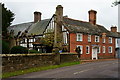
Church House, Lingfield, Sussex
Standing beside the churchyard, 'Church House' was formerly the 'Tiger'; an inn.
Image: © Peter Trimming
Taken: 4 Nov 2011
0.04 miles
7
122, High Street, Lindfield
Built as a Wealden hall house in the late 14th century and probably served as the village inn from the late medieval period, initially known as the Michelbourne Arms after a local family of traders and adventurers part of whose crest contained a tiger from which the hostelry took its later name. The inn became prominent during the coaching area but lost trade in the 19th century and eventually closed in 1916 after which it was purchased by neighbouring All Saints Church. Originally renamed Church House it is back once more as being known as the Tiger. Beyond to the right are Image and Image
Image: © Simon Carey
Taken: 30 Aug 2015
0.04 miles
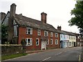
8
112-116, High Street, Lindfield
The house dates from the 17th century and was refronted in the Georgian era. Number 112 is on the right, 114 is in the middle and is also known as Oakley House, whilst 116 is to the right adjacent to Image
Image: © Simon Carey
Taken: 30 Aug 2015
0.05 miles
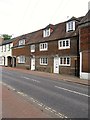
9
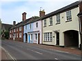
116a-120, High Street, Lindfield
116a is the yellow building also known as Tallow Cottage which was built in 1975. The pink and blue buildings are 118 and 120 respectively also known as Tiger Cottages and built in 1825. Beyond is Image
Image: © Simon Carey
Taken: 30 Aug 2015
0.05 miles
10

All Saints, Lindfield - Churchyard cross
Image: © John Salmon
Taken: 21 Oct 2014
0.05 miles