IMAGES TAKEN NEAR TO
Ardingly Road, HAYWARDS HEATH, RH16 2HZ
Introduction
This page details the photographs taken nearby to Ardingly Road, RH16 2HZ by members of the Geograph project.
The Geograph project started in 2005 with the aim of publishing, organising and preserving representative images for every square kilometre of Great Britain, Ireland and the Isle of Man.

There are currently over 7.5m images from over14,400 individuals and you can help contribute to the project by visiting https://www.geograph.org.uk
Image Map
Images are licensed for reuse under creativecommons.org/licenses/by-sa/2.0
Notes
- Clicking on the map will re-center to the selected point.
- The higher the marker number, the further away the image location is from the centre of the postcode.
Image Listing (18 Images Found)
Images are licensed for reuse under creativecommons.org/licenses/by-sa/2.0
Image
Details
Distance
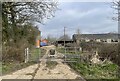
1
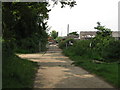
Hangman's Acre near Lindfield
The Sussex Ouse Valley Way makes a 90 degree turn here
Image: © Dave Spicer
Taken: 6 Jun 2009
0.01 miles
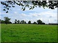
3
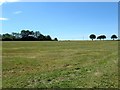
White Way Field/Upper Six Acres
The name of the fields according to Lindfield's 1845 tithe map that have been combined along with Image to the west to form larger unit. White Way Field was in the foreground adjacent to Image whilst Upper Six Acres was beyond the two oaks in view. To the east is Image whilst to the south of the footpath is Image
Image: © Simon Carey
Taken: 9 Aug 2015
0.04 miles
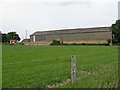
4
Hangman's Acre
Originally barn on the western side of a field of the same name, see Image Later became a farm though it appears some of the outbuildings are not let as business units.
Image: © Simon Carey
Taken: 9 Aug 2015
0.04 miles
5
Acre Cottage
Looking towards Acre Cottage from the footpath junction.
Image: © Chris Thomas-Atkin
Taken: 20 Mar 2021
0.07 miles
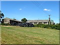
6
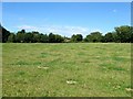
Lower Town Mead/White Way Field
The name of the fields according to Lindfield's 1845 tithe map that have been combined to form a larger unit. See Image and Image for alternative views. To the north west is Image to the south beyond Image is Image whilst the buildings at the far side of the field are Image
Image: © Simon Carey
Taken: 15 Aug 2015
0.08 miles
7
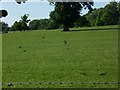
Fox in field near Hangman's Acre east of Lindfield
Image: © Shazz
Taken: 21 May 2011
0.08 miles
8
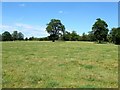
Two Oak Field/Hangman's Acre/Clapper mead/Two Acres
The name of the fields according to Lindfield's 1845 tithe map. In the foreground between the footpath and the lone oak is Two Oak Field. Beyond is Hangman's Acre then Clapper Mead with Two Acres occupying a small corner in the north western part of the merged field. To the south is Image, to the east is Image whilst to the west is Image
Image: © Simon Carey
Taken: 9 Aug 2015
0.15 miles
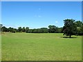
9
Seven Acres
The name of the field according to Lindfield's 1845 tithe map that is bounded by Image to the east, Image to the north and Image to the west.
Image: © Simon Carey
Taken: 9 Aug 2015
0.15 miles
10
Lower Town Mead
The name of the field according to Lindfield's 1845 tithe map that has been combined with Image to the east to form a larger unit. To the south west is Image
Image: © Simon Carey
Taken: 9 Aug 2015
0.16 miles